Supermarket nearby Tesco Superstore
United Kingdom
Supermarket nearby Tesco Superstore
Tesco Superstore
Ware Road, Hertford United Kingdom
contacts phone
:
+44
Latitude:
51.7984713
, Longitude:
-0.0720106
read more
nearest Supermarket
3.141 km
Tesco Superstore
5-6 West Street, Ware
Supermarket
read more
9.038 km
Lamex Foods Group
Turnford Place/Great Cambridge Rd, Broxbourne
Supermarket
read more
12.077 km
Asda Harlow Superstore
The Water Gardens, South Gate, Harlow
Supermarket
read more
12.171 km
Londis
280 High Street, Waltham Cross
Supermarket
read more
12.267 km
Sella Supermarket
7-8 Parkhouse Court, Hatfield
Supermarket
read more
12.269 km
Aldi
11 Parkhouse Court, Hatfield
Supermarket
read more
12.407 km
Lidl
1, Staple Tye Shopping Centre, Southern Way, Harlow
Supermarket
read more
13.072 km
Bargain Booze
17-18 The Stow, Harlow
Supermarket
read more
13.366 km
Tesco Esso Express
3 Bullsmoor Lane, Waltham Cross, Enfield
Supermarket
read more
14.162 km
Asda Stevenage Supercentre
Monkswood Way, Stevenage
Supermarket
read more
14.34 km
Tesco Express
15-17 Orchard Parade, Mutton Ln, Potters Bar
Supermarket
read more
14.52 km
Tesco Superstore
Church Langley Way, Harlow
Supermarket
read more
16.078 km
Waitrose
Bignell Corner, Potters Bar
Supermarket
read more
16.185 km
Londis
26 Crescent West, Barnet
Supermarket
read more
17.348 km
Sainsbury's
Colney Fields Shopping Park, London Colney, St Albans
Supermarket
read more
17.841 km
Tesco Express
95-97 Hatfield Road, St Albans
Supermarket
read more
18.396 km
Tesco Express
Coppice Row, Theydon Bois, Epping
Supermarket
read more
21.702 km
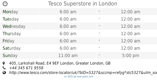
Tesco Superstore
405 Larkshall Road, London
Supermarket
read more
23.116 km
Pelny Brzuch
United Kingdom
Supermarket
read more
24.193 km
Asda Walthamstow Supermarket
Walthamstow, 19 Selborne Walk Shopping Centre, London
Supermarket
read more
24.24 km
International Supermarket
15-17 High Street, London
Supermarket
read more
24.794 km
Rodi Supermarket
168 Queens Road, London
Supermarket
read more
25.717 km
Bucharest Supermarket
69 Brent Street, London
Supermarket
read more
25.74 km
Londis
5 Redbridge Lane East, Ilford
Supermarket
read more
26.248 km
Kismat Supermarket
1 Sunnyside Terrace, London
Supermarket
read more
📑
all categories
Accounting
Administrative area level 1
Administrative area level 2
Airport
Amusement park
Aquarium
Art gallery
Atm
Bakery
Bank
Bar
Beauty salon
Bicycle store
Book store
Bowling alley
Bus station
Cafe
Campground
Car dealer
Car rental
Car repair
Car wash
Casino
Cemetery
Church
City hall
Clothing store
Colloquial area
Convenience store
Courthouse
Dentist
Department store
Doctor
Electrician
Electronics store
Embassy
Establishment
Finance
Fire station
Florist
Food
Funeral home
Furniture store
Gas station
General contractor
Grocery or supermarket
Gym
Hair care
Hardware store
Health
Hindu Temple
Home goods store
Hospital
Insurance agency
Jewelry store
Laundry
Lawyer
Library
Light rail station
Liquor store
Local government office
Locality
Locksmith
Lodging
Meal delivery
Meal takeaway
Mosque
Movie rental
Movie theater
Moving company
Museum
Natural feature
Neighborhood
Night club
Painter
Park
Parking
Pet store
Pharmacy
Physiotherapist
Place of worship
Plumber
Point of interest
Police
Political
Post office
Premise
Real estate agency
Restaurant
Roofing contractor
Route
Rv park, camping
School
Shoe store
Shopping mall
Spa
Stadium
Storage
Store
Subpremise
Subway station
Supermarket
Synagogue
Taxi stand
Train station
Transit station
Travel agency
University
Veterinary care
Zoo
administrative area level 3
administrative area level 4
sublocality level 1
↑