Supermarket nearby The Co-operative Food
United Kingdom
Supermarket nearby The Co-operative Food
The Co-operative Food
21-25 Hollyfield Road South, Sutton Coldfield Vereinigtes Königreich
contacts phone
:
+44
Latitude:
52.5601036
, Longitude:
-1.8024839
read more
nearest Supermarket
454 m
West Midlands Co-operative Society Ltd
59 Reddicap Hill, Sutton Coldfield
Supermarket
read more
1.067 km
Costcutter
Fircroft Filling Station/Coleshill Rd, Sutton Coldfield
Supermarket
read more
1.227 km
Tesco Esso Express
Whitehouse Common Road, Sutton Coldfield
Supermarket
read more
1.481 km
ALDI Sutton Coldfield
101 The Parade, Sutton Coldfield
Supermarket
read more
1.623 km
Iceland Foods
Birmingham Road, Sutton Coldfield
Supermarket
read more
1.644 km
Tesco Express
3 Birmingham Road, Sutton Coldfield
Supermarket
read more
2.34 km
Londis
92 Calder Drive, Birmingham
Supermarket
read more
2.947 km
Lifestyle express
92B Boldmere Road, Sutton Coldfield
Supermarket
read more
2.995 km
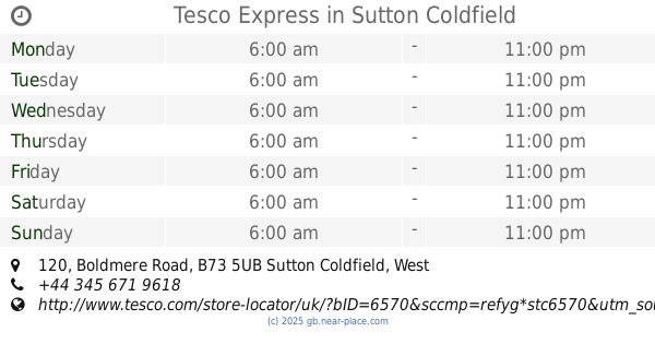
Tesco Express
120 Boldmere Road, Sutton Coldfield
Supermarket
read more
3.085 km
Sainsbury's
346 Birmingham Road, Sutton Coldfield
Supermarket
read more
3.085 km
Sainsbury's
346 Birmingham Road, The Royal Town of Sutton Coldfield, Sutton Coldfield
Supermarket
read more
3.223 km
Co-op Food & Supermarket, Sutton Coldfield, Birmingham
441 Birmingham Road, The Royal Town of Sutton Coldfield
Supermarket
read more
3.223 km
Co-op Food & Supermarket, Sutton Coldfield, Birmingham
441 Birmingham Road, Sutton Coldfield
Supermarket
read more
3.24 km
Central England Co-operative Sutton Coldfield Supermarket
441 Birmingham Road, Sutton Coldfield
Supermarket
read more
3.24 km
Co-op Food Supermarket, Birmingham Road, Sutton Coldfield
441 Birmingham Road, The Royal Town of Sutton Coldfield
Supermarket
read more
3.24 km
Co-op Food Supermarket, Birmingham Road, Sutton Coldfield
441 Birmingham Road, Sutton Coldfield
Supermarket
read more
3.364 km
Sainsbury's
30 Mere Green Road, Sutton Coldfield
Supermarket
read more
3.395 km
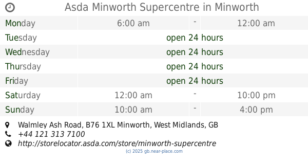
Asda Minworth Supercentre
Walmley Ash Road, Sutton Coldfield
Supermarket
read more
3.418 km
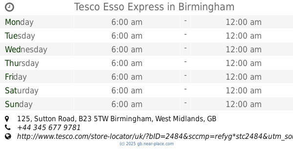
Tesco Esso Express
125 Sutton Road, Birmingham
Supermarket
read more
4.393 km
Costcutter
63-65 Gravelly Lane, Birmingham
Supermarket
read more
4.545 km
Nisa Local
766-768 College Road, Birmingham
Supermarket
read more
4.73 km
Heron Foods
146 High Street, Erdington, Birmingham
Supermarket
read more
4.733 km
Sainsbury's
Castle Vale Retail Park, Chester Road, Birmingham
Supermarket
read more
5.47 km
ALDI
College Road, Birmingham
Supermarket
read more
5.521 km
Ashok Supermarket
517A Slade Road, Birmingham
Supermarket
read more
📑
all categories
Accounting
Administrative area level 1
Administrative area level 2
Airport
Amusement park
Aquarium
Art gallery
Atm
Bakery
Bank
Bar
Beauty salon
Bicycle store
Book store
Bowling alley
Bus station
Cafe
Campground
Car dealer
Car rental
Car repair
Car wash
Casino
Cemetery
Church
City hall
Clothing store
Colloquial area
Convenience store
Courthouse
Dentist
Department store
Doctor
Electrician
Electronics store
Embassy
Establishment
Finance
Fire station
Florist
Food
Funeral home
Furniture store
Gas station
General contractor
Grocery or supermarket
Gym
Hair care
Hardware store
Health
Hindu Temple
Home goods store
Hospital
Insurance agency
Jewelry store
Laundry
Lawyer
Library
Light rail station
Liquor store
Local government office
Locality
Locksmith
Lodging
Meal delivery
Meal takeaway
Mosque
Movie rental
Movie theater
Moving company
Museum
Natural feature
Neighborhood
Night club
Painter
Park
Parking
Pet store
Pharmacy
Physiotherapist
Place of worship
Plumber
Point of interest
Police
Political
Post office
Premise
Real estate agency
Restaurant
Roofing contractor
Route
Rv park, camping
School
Shoe store
Shopping mall
Spa
Stadium
Storage
Store
Subpremise
Subway station
Supermarket
Synagogue
Taxi stand
Train station
Transit station
Travel agency
University
Veterinary care
Zoo
administrative area level 3
administrative area level 4
sublocality level 1
↑