Bank nearby Lloyds Bank
United Kingdom
Bank nearby Lloyds Bank
Lloyds Bank
73 Henleaze Road, Westbury-on-trym, Bristol Zjednoczone Królestwo
contacts phone
:
+44
Latitude:
51.4855426
, Longitude:
-2.6117887
read more
nearest Bank
803 m
Cote Bank House
146 Eastfield Road, Bristol
Bank
read more
944 m
Barclays Bank
1 High Street, Bristol
Bank
read more
990 m
The Co-operative Bank
10 High Street, Bristol
Bank
read more
990 m
The Co-operative Bank
10 High St, Bristol
Bank
read more
990 m
Brittania
10 High Street, Bristol
Bank
read more
996 m
NatWest Bank
13 High Street, Bristol
Bank
read more
1.007 km
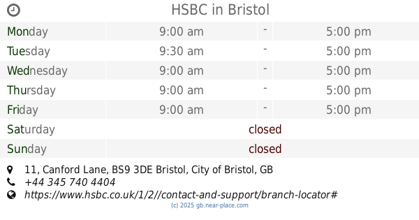
HSBC UK
11 Canford Lane, Bristol
Bank
read more
1.009 km
Lloyds Bank
15 High Street, Bristol
Bank
read more
1.015 km
HSBC
11 Canford Lane, Bristol
Bank
read more
1.729 km
Lloyds Bank
317 Gloucester Road, Bristol
Bank
read more
1.889 km
Lloyds Bank
163 Whiteladies Road, Bristol
Bank
read more
1.901 km
NatWest
72 Gloucester Road, Bristol
Bank
read more
1.985 km
Natwest
106 Whiteladies Road, Bristol
Bank
read more
2.023 km
HSBC
149 Whiteladies Road, Bristol
Bank
read more
2.053 km
Lloyds Bank
61 Gloucester Road, Bristol
Bank
read more
2.414 km
Halifax
54 Whiteladies Road, Clifton, Bristol
Bank
read more
2.461 km
RBS
50 Whiteladies Road, Bristol
Bank
read more
2.637 km
Handelsbanken
Whiteladies House, 51-55 Whiteladies Road, Bristol
Bank
read more
2.839 km
HSBC
27 Gloucester Road North, Filton, Avon, Bristol
Bank
read more
2.839 km
HSBC UK
27 Gloucester Road North, Bristol
Bank
read more
2.891 km
Allied Irish Bank (GB)
19 Whiteladies Road, Bristol
Bank
read more
3.176 km
The Co-Operative Bank
Surrey Street, Bristol
Bank
read more
3.269 km
Co-operative & Community Finance
15 York Street, Bristol
Bank
read more
3.473 km
Nationwide
Cabot Circus, Bristol
Bank
read more
3.779 km
NatWest Bank
4 Church Road, Bristol
Bank
read more
📑
all categories
Accounting
Administrative area level 1
Administrative area level 2
Airport
Amusement park
Aquarium
Art gallery
Atm
Bakery
Bank
Bar
Beauty salon
Bicycle store
Book store
Bowling alley
Bus station
Cafe
Campground
Car dealer
Car rental
Car repair
Car wash
Casino
Cemetery
Church
City hall
Clothing store
Colloquial area
Convenience store
Courthouse
Dentist
Department store
Doctor
Electrician
Electronics store
Embassy
Establishment
Finance
Fire station
Florist
Food
Funeral home
Furniture store
Gas station
General contractor
Grocery or supermarket
Gym
Hair care
Hardware store
Health
Hindu Temple
Home goods store
Hospital
Insurance agency
Jewelry store
Laundry
Lawyer
Library
Light rail station
Liquor store
Local government office
Locality
Locksmith
Lodging
Meal delivery
Meal takeaway
Mosque
Movie rental
Movie theater
Moving company
Museum
Natural feature
Neighborhood
Night club
Painter
Park
Parking
Pet store
Pharmacy
Physiotherapist
Place of worship
Plumber
Point of interest
Police
Political
Post office
Premise
Real estate agency
Restaurant
Roofing contractor
Route
Rv park, camping
School
Shoe store
Shopping mall
Spa
Stadium
Storage
Store
Subpremise
Subway station
Supermarket
Synagogue
Taxi stand
Train station
Transit station
Travel agency
University
Veterinary care
Zoo
administrative area level 3
administrative area level 4
sublocality level 1
↑