Bar nearby Galyons Bar and Kitchen
United Kingdom
Bar nearby Galyons Bar and Kitchen
Galyons Bar and Kitchen
Gallions Hotel, Albert Basin Way, London Vereinigtes Königreich
contacts phone
:
+44
Latitude:
51.5067992
, Longitude:
0.0731278
read more
nearest Bar
873 m
The California
12 Albert Road, London
Bar
read more
1.225 km
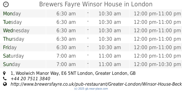
Brewers Fayre Winsor House
1 Woolwich Manor Way, London
Bar
read more
1.285 km
Henley Arms
268 Albert Road, London
Bar
read more
1.363 km
Tollgate Tavern
16 Mary Rose Mall, London
Bar
read more
1.633 km
Club Da Boss
116-118 Woolwich High Street, London
Bar
read more
1.708 km
The Mitre
United Kingdom
Bar
read more
1.746 km
The Castle Tavern
179 Powis Street, London
Bar
read more
2.158 km
Thefreehost
1 Spindle Close, London
Bar
read more
2.21 km
Yi-Ban
London Regatta Centre, 1010 Dockside Road, London
Bar
read more
2.213 km
MOXY London Excel
1014 Dockside Road, London
Bar
read more
2.313 km
Black & White Lounge
2a Jenkins Lane, Barking
Bar
read more
2.341 km
Fox at Connaught
THE Connaught House Hotel, Lynx Way, London
Bar
read more
2.467 km
St Clairs Kitchen
9 Warspite Road, London
Bar
read more
2.619 km
WXYZ Bar
Aloft London Excel, One Eastern Gateway, Royal Victoria Dock, London
Bar
read more
2.757 km
The Boathouse Cafe and Bar
80 Abbey Road, Barking
Bar
read more
2.855 km
Red Lion E6
80 High Street South, London
Bar
read more
3.107 km
The Royal Oak Pub
54 Charlton Lane, London
Bar
read more
3.156 km
Five Rivers - Authentic North Indian Cuisine
Plumstead Common Road/35 The Slade, London
Bar
read more
3.179 km
Feng Restaurant
443-445 Barking Road, London
Bar
read more
3.182 km
The Millers Well
419-421 Barking Road, London
Bar
read more
3.239 km
Hair salon
355A Barking Road, London
Bar
read more
3.322 km
Tavern Snacks
Unit 2/Anchorage Point/90 Anchor And Hope La, London
Bar
read more
3.571 km
boleyn pub
Barking Road, London
Bar
read more
3.572 km
The Boleyn Tavern
1 Barking Road, London
Bar
read more
3.58 km
Tribal Hostel London
1 Barking Road, London
Bar
read more
📑
all categories
Accounting
Administrative area level 1
Administrative area level 2
Airport
Amusement park
Aquarium
Art gallery
Atm
Bakery
Bank
Bar
Beauty salon
Bicycle store
Book store
Bowling alley
Bus station
Cafe
Campground
Car dealer
Car rental
Car repair
Car wash
Casino
Cemetery
Church
City hall
Clothing store
Colloquial area
Convenience store
Courthouse
Dentist
Department store
Doctor
Electrician
Electronics store
Embassy
Establishment
Finance
Fire station
Florist
Food
Funeral home
Furniture store
Gas station
General contractor
Grocery or supermarket
Gym
Hair care
Hardware store
Health
Hindu Temple
Home goods store
Hospital
Insurance agency
Jewelry store
Laundry
Lawyer
Library
Light rail station
Liquor store
Local government office
Locality
Locksmith
Lodging
Meal delivery
Meal takeaway
Mosque
Movie rental
Movie theater
Moving company
Museum
Natural feature
Neighborhood
Night club
Painter
Park
Parking
Pet store
Pharmacy
Physiotherapist
Place of worship
Plumber
Point of interest
Police
Political
Post office
Premise
Real estate agency
Restaurant
Roofing contractor
Route
Rv park, camping
School
Shoe store
Shopping mall
Spa
Stadium
Storage
Store
Subpremise
Subway station
Supermarket
Synagogue
Taxi stand
Train station
Transit station
Travel agency
University
Veterinary care
Zoo
administrative area level 3
administrative area level 4
sublocality level 1
↑