Bar nearby The Crown Hotel
United Kingdom
Bar nearby The Crown Hotel
The Crown Hotel
Varteg Road, Pontypool Det Forenede Kongerige
contacts phone
:
+44
Latitude:
51.7497678
, Longitude:
-3.0649084
read more
nearest Bar
2.791 km
The New Inn
130 High Street, Abersychan, Pontypool
Bar
read more
4.66 km
Little Crown Inn
Elled Road, Wainfelin, Pontypool
Bar
read more
5.255 km
The Glasgow Phoenix Abertillery
20 Market Street, Abertillery
Bar
read more
5.359 km
Heritage Fish Bar
Crown Buildings, George Street, Pontypool
Bar
read more
5.658 km
Pontypool Working Mens Club
Top Broadway, Pontypool
Bar
read more
9.87 km
GreenMeadow Golf and Country Club
Tre-Herbert Road, Cwmbran
Bar
read more
10.303 km
Ruby's Bar and Grill
Leadon Court, Cwmbran
Bar
read more
10.394 km
Picture House
Market Street, Ebbw Vale
Bar
read more
11.016 km
Otter
Bridge Street, Newbridge
Bar
read more
11.037 km
Harvester Cwmbran
5, Leisure at Cwmbran, Cwmbran Leisure Park, 4 Glyndwr Road, Cwmbran
Bar
read more
12.117 km
Neuadd Wen
Bedwellty Road, Bedwellty
Bar
read more
12.163 km
Crown Inn
3 Dan-Y-Rhiw Terrace, Abercarn, Newport
Bar
read more
12.217 km
The Dorallt Inn
Henllys, Cwmbran
Bar
read more
12.502 km
Blinkin Owl
Oxtens, Cwmbran
Bar
read more
12.627 km
Llwyncelyn Cylch Ti a Fi
Coedeva and Hollybush Community Hall, Penylan Roundabout, Cwmbran
Bar
read more
13.052 km
The Square Royale LTD
25 High Street, Bargoed
Bar
read more
13.41 km
The Cwmcarn Hotel
Newport Road, Cwmcarn, Caerphilly
Bar
read more
15.222 km
Darran
2 Saint Mary Street, Risca
Bar
read more
15.822 km
The Angel Inn
Thomas Street, Maesycwmmer
Bar
read more
16.586 km
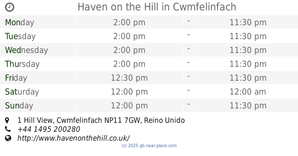
Haven on the Hill
1 Hill View, Cwmfelinfach
Bar
read more
16.724 km
The Beech Tree Hotel
43 Bedwlwyn Road, Ystrad Mynach, Hengoed
Bar
read more
17.156 km
Penallta Rugby Football Club
Caerphilly Road, Ystrad Mynach
Bar
read more
17.616 km
The Spike Bar
Caerleon, Newport
Bar
read more
18.169 km
Coach & Horses Inn
Cwm Crawnon Road, Crickhowell
Bar
read more
20.681 km
The Groes Wen Inn
Penhow, Caldicot
Bar
read more
📑
all categories
Accounting
Administrative area level 1
Administrative area level 2
Airport
Amusement park
Aquarium
Art gallery
Atm
Bakery
Bank
Bar
Beauty salon
Bicycle store
Book store
Bowling alley
Bus station
Cafe
Campground
Car dealer
Car rental
Car repair
Car wash
Casino
Cemetery
Church
City hall
Clothing store
Colloquial area
Convenience store
Courthouse
Dentist
Department store
Doctor
Electrician
Electronics store
Embassy
Establishment
Finance
Fire station
Florist
Food
Funeral home
Furniture store
Gas station
General contractor
Grocery or supermarket
Gym
Hair care
Hardware store
Health
Hindu Temple
Home goods store
Hospital
Insurance agency
Jewelry store
Laundry
Lawyer
Library
Light rail station
Liquor store
Local government office
Locality
Locksmith
Lodging
Meal delivery
Meal takeaway
Mosque
Movie rental
Movie theater
Moving company
Museum
Natural feature
Neighborhood
Night club
Painter
Park
Parking
Pet store
Pharmacy
Physiotherapist
Place of worship
Plumber
Point of interest
Police
Political
Post office
Premise
Real estate agency
Restaurant
Roofing contractor
Route
Rv park, camping
School
Shoe store
Shopping mall
Spa
Stadium
Storage
Store
Subpremise
Subway station
Supermarket
Synagogue
Taxi stand
Train station
Transit station
Travel agency
University
Veterinary care
Zoo
administrative area level 3
administrative area level 4
sublocality level 1
↑