Campground nearby Janson Fishery Caravan & Camping
United Kingdom
Campground nearby Janson Fishery Caravan & Camping
Janson Fishery Caravan & Camping
Redmile Lane, Elton Det Forenede Kongerige
contacts phone
:
+44
Latitude:
52.9372154
, Longitude:
-0.8745665
read more
nearest Campground
5.757 km
Little Langar Lodge & Landings Campsite
Vale Lodge, Harby Road, Nottingham
Campground
read more
14.546 km
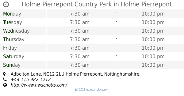
Holme Pierrepont Country Park
Adbolton Lane, Holme Pierrepont, Nottingham
Campground
read more
14.546 km
Holme Pierrepont Country Park, home of The National Water Sports Centre
Adbolton Lane, Holme Pierrepont, Nottingham
Campground
read more
14.569 km
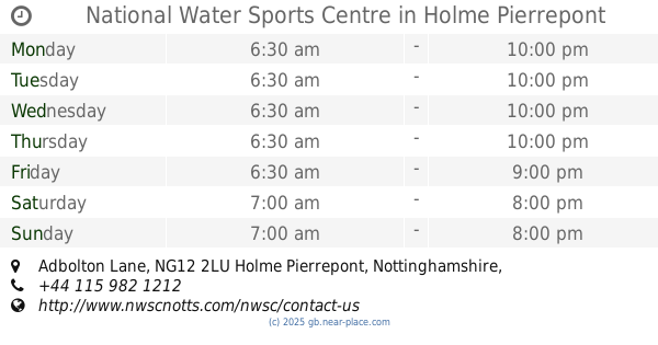
National Water Sports Centre
Adbolton Lane, Holme Pierrepont, Nottingham
Campground
read more
15.208 km
Holme Pierrepoint Campsite
Unnamed Road 5AX, Nottingham
Campground
read more
15.208 km
Holme Pierrepont Campsite
Unnamed Road 5AX, Nottingham
Campground
read more
15.249 km
Caravan Park and Campsite
Unnamed Road 5AX, Nottingham
Campground
read more
20.515 km
Salterford Dam CL
Salterford Dam CL, Salterford Lane, Calverton, Nottingham
Campground
read more
24.906 km
Stonepit Wood Scout Campsite
Soldiers Lane, Gotham
Campground
read more
25.71 km
Greendale Farm Caravan & Camping Park
Pickwell Lane, Whissendine, Oakham
Campground
read more
25.887 km
Brackenwood
Dark Lane, Linby
Campground
read more
28.399 km
Rutland Escapes
Ranksborough Drive, Oakham
Campground
read more
33.243 km
Rutland camping ground
1 Hambleton Road, Egleton, Oakham
Campground
read more
34.534 km
Green Camp
Castle Donington, Derby
Campground
read more
35.208 km
Black Campsite
Castle Donington, Derby
Campground
read more
36.018 km
Quiet/Eco Campsite
Castle Donington, Derby
Campground
read more
36.209 km
Oaks at chamwood
Charley Road, Shepshed, Loughborough
Campground
read more
36.395 km
Hartsholme Country Park campsite
Hartsholme Country Park, Skellingthorpe Road, Lincoln
Campground
read more
38.436 km
Drum Hill Scout Campsite
Morley Lane, Little Eaton, Derby
Campground
read more
46.275 km
Cherry Lodge
Mercia Marina, Findern Lane, Willington, Derby
Campground
read more
46.288 km
Rowan Lodge
Mercia Marina, Findern Lane, Willington, Derby
Campground
read more
46.321 km
Hazel Lodge
Mercia Marina, Findern Lane, Willington, Derby
Campground
read more
46.334 km
Acer Lodge
Mercia Marina, Findern Lane, Willington, Derby
Campground
read more
56.705 km
Ferry Meadows Caravan and Motorhome Club Site
Ham Lane, Peterborough
Campground
read more
67.197 km
Fox Hagg Farm Campsite
Sheffield
Campground
read more
📑
all categories
Accounting
Administrative area level 1
Administrative area level 2
Airport
Amusement park
Aquarium
Art gallery
Atm
Bakery
Bank
Bar
Beauty salon
Bicycle store
Book store
Bowling alley
Bus station
Cafe
Campground
Car dealer
Car rental
Car repair
Car wash
Casino
Cemetery
Church
City hall
Clothing store
Colloquial area
Convenience store
Courthouse
Dentist
Department store
Doctor
Electrician
Electronics store
Embassy
Establishment
Finance
Fire station
Florist
Food
Funeral home
Furniture store
Gas station
General contractor
Grocery or supermarket
Gym
Hair care
Hardware store
Health
Hindu Temple
Home goods store
Hospital
Insurance agency
Jewelry store
Laundry
Lawyer
Library
Light rail station
Liquor store
Local government office
Locality
Locksmith
Lodging
Meal delivery
Meal takeaway
Mosque
Movie rental
Movie theater
Moving company
Museum
Natural feature
Neighborhood
Night club
Painter
Park
Parking
Pet store
Pharmacy
Physiotherapist
Place of worship
Plumber
Point of interest
Police
Political
Post office
Premise
Real estate agency
Restaurant
Roofing contractor
Route
Rv park, camping
School
Shoe store
Shopping mall
Spa
Stadium
Storage
Store
Subpremise
Subway station
Supermarket
Synagogue
Taxi stand
Train station
Transit station
Travel agency
University
Veterinary care
Zoo
administrative area level 3
administrative area level 4
sublocality level 1
↑