Campground nearby Jollydays Glamping
Coronavirus disease (COVID-19) Situation
confirmed cases
24910387
deaths
232112
United Kingdom
Campground nearby Jollydays Glamping
Jollydays Glamping
Buttercrambe Road, York Vereinigtes Königreich
contacts phone
:
+44
Latitude:
54.005315
, Longitude:
-0.91471
read more
nearest Campground
2.748 km
Street Farm Holiday Cottages
Full Sutton, York
Campground
read more
4.042 km
Foxhill Park
Zjednoczone Królestwo
Campground
read more
4.042 km
Foxhill Park
United Kingdom
Campground
read more
4.042 km
Foxhill Park
Reino Unido
Campground
read more
4.042 km
Foxhill Park
Det Forenede Kongerige
Campground
read more
4.042 km
Foxhill Park
Vereinigtes Königreich
Campground
read more
4.151 km
Claxton Grange
Claxton, York
Campground
read more
4.939 km
Harton Caravans
Harton Caravans, Pear Tree Farm, Harton
Campground
read more
4.973 km
York Holiday & Cycle Stop
Holtby Lane, Holtby, York
Campground
read more
5.585 km
Fangfoss Park
Fangfoss, York
Campground
read more
7.264 km
White Rose Club
Unnamed Road, Flaxton, York
Campground
read more
7.464 km
York Beechwood Grange Caravan and Motorhome Club Site
York Beechwood Grange Club Site, Malton Road, York, North Yorkshire
Campground
read more
8.452 km
The Old Coach House & Coach House Cottages York
The Squirrels, Hull Road, Wilberfoss, York
Campground
read more
8.474 km
Wolds Edge Holiday Lodges
Main Street, Bishop Wilton, York
Campground
read more
12.434 km
York Rowntree Park Caravan and Motorhome Club Site
Terry Avenue, York
Campground
read more
12.684 km
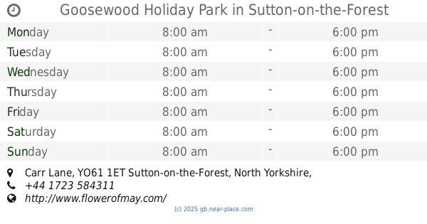
Goosewood Holiday Park
Carr Lane, Sutton-on-the-Forest, York
Campground
read more
13.267 km
i Yorkshire Holiday
The Mt, York
Campground
read more
13.661 km
Acorn Glade Glamping
Kidd Lane, Melbourne, York
Campground
read more
13.812 km
R Voakes Farmer
Melbourne Grange Farm, Melbourne, York
Campground
read more
14.031 km
Castle Howard Lakeside Holiday Park
Castle Howard, York
Campground
read more
14.732 km
Riverside Caravan & Camping Site
Ferry Lane, York
Campground
read more
15.784 km
Millbridge Farm Camping & Caravan Park
Howden Lane, Naburn, York
Campground
read more
16.774 km
Moor End Farm
Moor End, Acaster Malbis, York
Campground
read more
18.625 km
Home Farm
Stillingfleet, York
Campground
read more
20.215 km
Peel Park Camping
Crayke Road, Brandsby, York
Campground
read more
📑
all categories
Accounting
Administrative area level 1
Administrative area level 2
Airport
Amusement park
Aquarium
Art gallery
Atm
Bakery
Bank
Bar
Beauty salon
Bicycle store
Book store
Bowling alley
Bus station
Cafe
Campground
Car dealer
Car rental
Car repair
Car wash
Casino
Cemetery
Church
City hall
Clothing store
Colloquial area
Convenience store
Courthouse
Dentist
Department store
Doctor
Electrician
Electronics store
Embassy
Establishment
Finance
Fire station
Florist
Food
Funeral home
Furniture store
Gas station
General contractor
Grocery or supermarket
Gym
Hair care
Hardware store
Health
Hindu Temple
Home goods store
Hospital
Insurance agency
Jewelry store
Laundry
Lawyer
Library
Light rail station
Liquor store
Local government office
Locality
Locksmith
Lodging
Meal delivery
Meal takeaway
Mosque
Movie rental
Movie theater
Moving company
Museum
Natural feature
Neighborhood
Night club
Painter
Park
Parking
Pet store
Pharmacy
Physiotherapist
Place of worship
Plumber
Point of interest
Police
Political
Post office
Premise
Real estate agency
Restaurant
Roofing contractor
Route
Rv park, camping
School
Shoe store
Shopping mall
Spa
Stadium
Storage
Store
Subpremise
Subway station
Supermarket
Synagogue
Taxi stand
Train station
Transit station
Travel agency
University
Veterinary care
Zoo
administrative area level 3
administrative area level 4
sublocality level 1
↑