Lodging nearby Toast Lettings
United Kingdom
Lodging nearby Toast Lettings
Toast Lettings
ST 8, Dragonville Industrial Park, Durham United Kingdom
contacts phone
:
+44
Latitude:
54.7804797
, Longitude:
-1.5409404
read more
nearest Lodging
141 m
Gilesgate Moor Hotel
Teasdale Terrace, Durham
Lodging
read more
661 m
Bannatyne Hotel Durham
Eden Terrace, Durham
Lodging
read more
749 m
Premier Inn Durham East
Broomside Park, Belmont Industrial Estate, Durham
Lodging
read more
749 m
Premier Inn Durham East
Belmont Industrial Estate, Broomside Park, Durham
Lodging
read more
877 m
Moor End Guest House
7-8 Moor End Terrace, Durham
Lodging
read more
1.075 km
Rose Cottage
127 Gilesgate, Durham
Lodging
read more
1.086 km
Fern Cottage
129 Gilesgate, Durham
Lodging
read more
1.324 km
Broome Road
56 Broome Road, Durham
Lodging
read more
1.4 km
Travelodge Durham
9 Station Lane, Durham
Lodging
read more
1.439 km
The Annexe
Durham,
Lodging
read more
1.728 km
Durham Apartment
62 Wantage Road, Durham
Lodging
read more
1.775 km
Mrs Koltai's B&B
10 Gilesgate, Durham
Lodging
read more
1.781 km
Cathedral View Town House
212 Gilesgate, Durham
Lodging
read more
1.823 km
Hodgson G
Sands House/The Sands, Durham
Lodging
read more
1.854 km
The Town House
34 Old Elvet, Durham
Lodging
read more
1.855 km
Norman Lodge
Masonic Hall, Durham
Lodging
read more
1.893 km
66 Claypath
66 Claypath, Durham
Lodging
read more
2.006 km
Hotel Indigo Durham
9 Old Elvet, Durham
Lodging
read more
2.01 km
Durham Cathedral View Suites
Belle Vue Court, Claypath, Durham
Lodging
read more
2.048 km
Durham Marriott Hotel Royal County
Old Elvet, Durham
Lodging
read more
2.17 km
Luxurious Apartment in Durham City
10B Church Street, Durham
Lodging
read more
2.229 km
Cuthberts Rest
42 Oswald Court, Durham
Lodging
read more
2.232 km
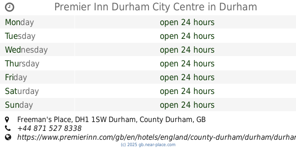
Premier Inn Durham City Centre
Freeman's Place, Durham
Lodging
read more
2.596 km
Staindrop Road
38 Staindrop Road, Durham
Lodging
read more
3.194 km
Hawthorn House
Durham
Lodging
read more
📑
all categories
Accounting
Administrative area level 1
Administrative area level 2
Airport
Amusement park
Aquarium
Art gallery
Atm
Bakery
Bank
Bar
Beauty salon
Bicycle store
Book store
Bowling alley
Bus station
Cafe
Campground
Car dealer
Car rental
Car repair
Car wash
Casino
Cemetery
Church
City hall
Clothing store
Colloquial area
Convenience store
Courthouse
Dentist
Department store
Doctor
Electrician
Electronics store
Embassy
Establishment
Finance
Fire station
Florist
Food
Funeral home
Furniture store
Gas station
General contractor
Grocery or supermarket
Gym
Hair care
Hardware store
Health
Hindu Temple
Home goods store
Hospital
Insurance agency
Jewelry store
Laundry
Lawyer
Library
Light rail station
Liquor store
Local government office
Locality
Locksmith
Lodging
Meal delivery
Meal takeaway
Mosque
Movie rental
Movie theater
Moving company
Museum
Natural feature
Neighborhood
Night club
Painter
Park
Parking
Pet store
Pharmacy
Physiotherapist
Place of worship
Plumber
Point of interest
Police
Political
Post office
Premise
Real estate agency
Restaurant
Roofing contractor
Route
Rv park, camping
School
Shoe store
Shopping mall
Spa
Stadium
Storage
Store
Subpremise
Subway station
Supermarket
Synagogue
Taxi stand
Train station
Transit station
Travel agency
University
Veterinary care
Zoo
administrative area level 3
administrative area level 4
sublocality level 1
↑