Atm nearby ATM
United Kingdom
Atm nearby ATM
ATM
55 Cookridge Street, Leeds Vereinigtes Königreich
contacts phone
:
+44
Latitude:
53.8023286
, Longitude:
-1.5473109
read more
nearest Atm
198 m
Sainsbury's Bank ATM
41 Wade Lane, Leeds
Atm
read more
345 m
ATM (Nisa - Sky Plaza)
Claypit Lane, Leeds
Atm
read more
400 m
ATM (The Fenton)
161 Woodhouse Lane, Leeds
Atm
read more
458 m
ATM
MSU3, The Core, Leeds
Atm
read more
471 m
NatWest ATM
8 Park Row, Leeds
Atm
read more
493 m
ATM
69 Albion St،Leeds
Atm
read more
495 m
ATM
33 Park Row،Leeds
Atm
read more
520 m
ATM
28 The Headrow, Leeds
Atm
read more
556 m
Barclays ATM
Faculty Of Medicine And Health, Leeds University, Leeds
Atm
read more
587 m
ATM
28 Saint Paul's Street, Leeds
Atm
read more
601 m
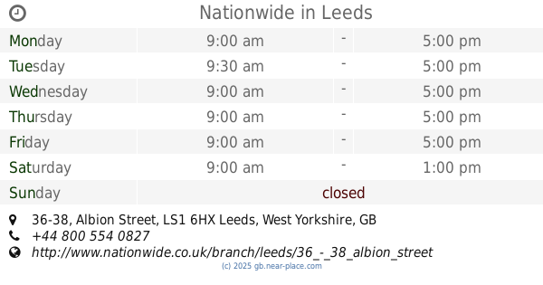
Nationwide
36-38 Albion Street, Leeds
Atm
read more
605 m
Santander ATM
1A Commercial Street, Leeds
Atm
read more
648 m
ATM
25 Blenheim Terrace, Leeds
Atm
read more
721 m
ATM
Aire Street, Leeds
Atm
read more
760 m
ATM (Yorkshire Building Society)
150 Briggate, Leeds
Atm
read more
768 m
ATM
68 Wellington Street, Leeds
Atm
read more
781 m
ATM
Leeds Uni, Leeds Uni Student Union, Leeds, University Square
Atm
read more
799 m
ATM
28-34 George Street, Leeds
Atm
read more
878 m
ATM
116 Wellington Street, Leeds
Atm
read more
882 m
ATM
37 New York Street, Leeds
Atm
read more
885 m
Brooks News
1 Neville Street, Leeds
Atm
read more
898 m
ATM
2 Sovereign Place, Leeds
Atm
read more
1.094 km
ATM
79 Raglan Road, Leeds
Atm
read more
1.132 km
Cash Machine
207 Clarendon Road, Leeds
Atm
read more
1.299 km
ATM
The Gateway North, Crown Point Road, Leeds
Atm
read more
📑
all categories
Accounting
Administrative area level 1
Administrative area level 2
Airport
Amusement park
Aquarium
Art gallery
Atm
Bakery
Bank
Bar
Beauty salon
Bicycle store
Book store
Bowling alley
Bus station
Cafe
Campground
Car dealer
Car rental
Car repair
Car wash
Casino
Cemetery
Church
City hall
Clothing store
Colloquial area
Convenience store
Courthouse
Dentist
Department store
Doctor
Electrician
Electronics store
Embassy
Establishment
Finance
Fire station
Florist
Food
Funeral home
Furniture store
Gas station
General contractor
Grocery or supermarket
Gym
Hair care
Hardware store
Health
Hindu Temple
Home goods store
Hospital
Insurance agency
Jewelry store
Laundry
Lawyer
Library
Light rail station
Liquor store
Local government office
Locality
Locksmith
Lodging
Meal delivery
Meal takeaway
Mosque
Movie rental
Movie theater
Moving company
Museum
Natural feature
Neighborhood
Night club
Painter
Park
Parking
Pet store
Pharmacy
Physiotherapist
Place of worship
Plumber
Point of interest
Police
Political
Post office
Premise
Real estate agency
Restaurant
Roofing contractor
Route
Rv park, camping
School
Shoe store
Shopping mall
Spa
Stadium
Storage
Store
Subpremise
Subway station
Supermarket
Synagogue
Taxi stand
Train station
Transit station
Travel agency
University
Veterinary care
Zoo
administrative area level 3
administrative area level 4
sublocality level 1
↑