Bank nearby Barclays Bank
United Kingdom
Bank nearby Barclays Bank
Barclays Bank
40 Wellington Road, London Det Forenede Kongerige
contacts phone
:
+44
Latitude:
51.5333497
, Longitude:
-0.172454
read more
nearest Bank
896 m
Barclays Bank
320/322 Elgin Avenue, London
Bank
read more
1.145 km
Barclays Bank
131 Finchley Road, London
Bank
read more
1.257 km
Santander
388-390 Edgware Road, London
Bank
read more
1.303 km
Santander
8 Harben Parade, Finchley Road, Swiss Cottage, London
Bank
read more
1.401 km
Halifax
169A Finchley Road, Swiss Cottage, London
Bank
read more
1.455 km
ATM (Regents College)
Inner Circle, London
Bank
read more
1.485 km
NatWest Bank
106 Finchley Rd, London
Bank
read more
1.595 km
HSBC
186 Baker Street, London
Bank
read more
1.611 km
HSBC
122 Finchley Road, London
Bank
read more
1.682 km
ATM Machine
Unnamed, London
Bank
read more
1.775 km
HSBC
171 Edgware Road, London
Bank
read more
1.835 km
Halifax
149, 153 Kilburn High Rd, London
Bank
read more
1.879 km
Barclays Bank
127 Edgware Road, London
Bank
read more
1.899 km
Hellenic
291 Finchley Road, London
Bank
read more
1.93 km
TSB Bank
68 Baker Street, London
Bank
read more
2.023 km
Allied Irish Bank (GB)
202 Finchley Road, London
Bank
read more
2.066 km
Aspinall Capital Advisors
Portman Towers, London
Bank
read more
2.08 km
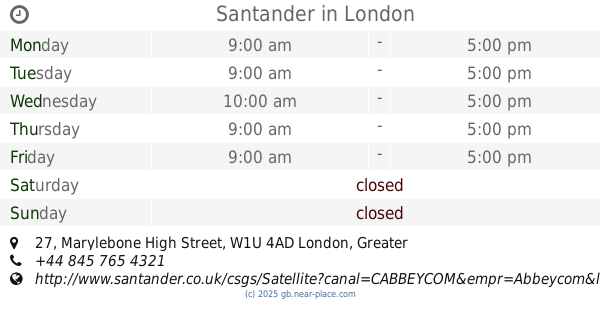
Santander
27 Marylebone High Street, London
Bank
read more
2.157 km
NatWest
10 Marylebone High Street, London
Bank
read more
2.167 km
Lloyds Bank
8 Marylebone High Street, London
Bank
read more
2.226 km
National Bank Of Kuwait
13 George Street, London
Bank
read more
2.294 km
National Bank Of Kuwait
7 Portman Square, London
Bank
read more
2.315 km
البنك الوطني لندن
6ld, 4 Portman Square, London
Bank
read more
2.318 km
BLME
12 Manchester Square, London
Bank
read more
2.333 km
NatWest Bank
1 Portman Square, London
Bank
read more
📑
all categories
Accounting
Administrative area level 1
Administrative area level 2
Airport
Amusement park
Aquarium
Art gallery
Atm
Bakery
Bank
Bar
Beauty salon
Bicycle store
Book store
Bowling alley
Bus station
Cafe
Campground
Car dealer
Car rental
Car repair
Car wash
Casino
Cemetery
Church
City hall
Clothing store
Colloquial area
Convenience store
Courthouse
Dentist
Department store
Doctor
Electrician
Electronics store
Embassy
Establishment
Finance
Fire station
Florist
Food
Funeral home
Furniture store
Gas station
General contractor
Grocery or supermarket
Gym
Hair care
Hardware store
Health
Hindu Temple
Home goods store
Hospital
Insurance agency
Jewelry store
Laundry
Lawyer
Library
Light rail station
Liquor store
Local government office
Locality
Locksmith
Lodging
Meal delivery
Meal takeaway
Mosque
Movie rental
Movie theater
Moving company
Museum
Natural feature
Neighborhood
Night club
Painter
Park
Parking
Pet store
Pharmacy
Physiotherapist
Place of worship
Plumber
Point of interest
Police
Political
Post office
Premise
Real estate agency
Restaurant
Roofing contractor
Route
Rv park, camping
School
Shoe store
Shopping mall
Spa
Stadium
Storage
Store
Subpremise
Subway station
Supermarket
Synagogue
Taxi stand
Train station
Transit station
Travel agency
University
Veterinary care
Zoo
administrative area level 3
administrative area level 4
sublocality level 1
↑