Bank nearby HSBC
United Kingdom
Bank nearby HSBC
HSBC
108, Harrogate Road, LS7 4NU, Leeds, West Yorkshire, GB Vereinigtes Königreich
contacts phone
:
+44 345 740 4404
website:
www.hsbc.co.uk
Latitude:
53.8289925
, Longitude:
-1.5378109
larger map & directions
read more
nearest Bank
376 m
NatWest
52 Harrogate Road, Leeds
Bank
read more
1.587 km
Halifax
374 Harrogate Rd, Leeds
Bank
read more
1.587 km
Halifax
374 Harrogate Road, Leeds
Bank
read more
1.635 km
Barclays Bank
390 Harrogate Road, Leeds
Bank
read more
1.689 km
Lloyds Bank
404 Harrogate Road, Leeds
Bank
read more
2.02 km
Kcb
United Kingdom
Bank
read more
2.198 km
Misho
Block M Montague Burton Flats, F0.21, 23 Devon Road, Leeds
Bank
read more
2.501 km
Santander
77 Street Lane, Leeds
Bank
read more
2.541 km
Barclays Bank
25 Back Blenheim Terrace, Leeds
Bank
read more
2.719 km
TSB Bank
8 Otley Road, Leeds
Bank
read more
2.75 km
Santander
Leeds University Union, Lifton Place, Leeds
Bank
read more
2.779 km
NatWest
63 Otley Road, Leeds
Bank
read more
2.783 km
Halifax
5 North Lane, Leeds
Bank
read more
2.783 km
Halifax
5 North Ln, Leeds
Bank
read more
2.784 km
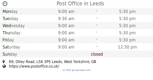
Post Office
3ps, 69 Otley Road, Leeds
Bank
read more
2.8 km
Handelsbanken Leeds Headingley
House, 2 North Lane, Leeds
Bank
read more
2.843 km
ATM
Clay Pit Lane, Leeds
Bank
read more
2.845 km
Yorkshire Bank
329 Harehills Lane, Leeds
Bank
read more
2.85 km
ATM (Leeds College Of Building)
North Street, Leeds
Bank
read more
2.93 km
Yorkshire Bank HQ
20 Merrion Way, Leeds
Bank
read more
3.005 km
Lloyds Bank
391-393 Harehills Lane, West Yorkshire, Leeds
Bank
read more
3.005 km
Lloyds Bank
391-393 Harehills Lane, Leeds
Bank
read more
3.412 km
RBS
27 Park Row, Leeds
Bank
read more
3.502 km
Halifax
18 King Edward Street, Leeds
Bank
read more
3.502 km
Halifax
18 King Edward St, Leeds
Bank
read more
📑
all categories
Accounting
Administrative area level 1
Administrative area level 2
Airport
Amusement park
Aquarium
Art gallery
Atm
Bakery
Bank
Bar
Beauty salon
Bicycle store
Book store
Bowling alley
Bus station
Cafe
Campground
Car dealer
Car rental
Car repair
Car wash
Casino
Cemetery
Church
City hall
Clothing store
Colloquial area
Convenience store
Courthouse
Dentist
Department store
Doctor
Electrician
Electronics store
Embassy
Establishment
Finance
Fire station
Florist
Food
Funeral home
Furniture store
Gas station
General contractor
Grocery or supermarket
Gym
Hair care
Hardware store
Health
Hindu Temple
Home goods store
Hospital
Insurance agency
Jewelry store
Laundry
Lawyer
Library
Light rail station
Liquor store
Local government office
Locality
Locksmith
Lodging
Meal delivery
Meal takeaway
Mosque
Movie rental
Movie theater
Moving company
Museum
Natural feature
Neighborhood
Night club
Painter
Park
Parking
Pet store
Pharmacy
Physiotherapist
Place of worship
Plumber
Point of interest
Police
Political
Post office
Premise
Real estate agency
Restaurant
Roofing contractor
Route
Rv park, camping
School
Shoe store
Shopping mall
Spa
Stadium
Storage
Store
Subpremise
Subway station
Supermarket
Synagogue
Taxi stand
Train station
Transit station
Travel agency
University
Veterinary care
Zoo
administrative area level 3
administrative area level 4
sublocality level 1
↑