Bar nearby College Farm
United Kingdom
Bar nearby College Farm
College Farm
Majors Road, Watchfield, Swindon Reino Unido
contacts phone
:
+44
Latitude:
51.6144865
, Longitude:
-1.636382
read more
nearest Bar
846 m
The Eagle Watchfield
Eagle Lane, Watchfield
Bar
read more
1.99 km
The King & Queen
Shrivenham Road, Longcot, Faringdon
Bar
read more
3.933 km
The Eagle Tavern
Little Coxwell, Faringdon
Bar
read more
5 km
The White Horse
Marsh Way, Faringdon
Bar
read more
6.083 km
Ruby Jacks
Market Place, 26, Faringdon
Bar
read more
6.386 km
Sudbury House - Four star Hotel
56 London Street, Faringdon
Bar
read more
7.945 km
The Blowing Stone
Kingston Lisle, Wantage
Bar
read more
8.915 km
Horse & Jockey
25 Faringdon Road, Stanford In The Vale, Faringdon, Oxfordshire
Bar
read more
9.804 km
19th Hole at Carswell
Carswell Golf and Country Club, Faringdon
Bar
read more
11.401 km
The Lamb at Buckland
The Vicarage, Buckland Road, Buckland, Faringdon
Bar
read more
12.652 km
The Trout at Tadpole Bridge
Buckland Road, Buckland Marsh, Faringdon
Bar
read more
12.951 km
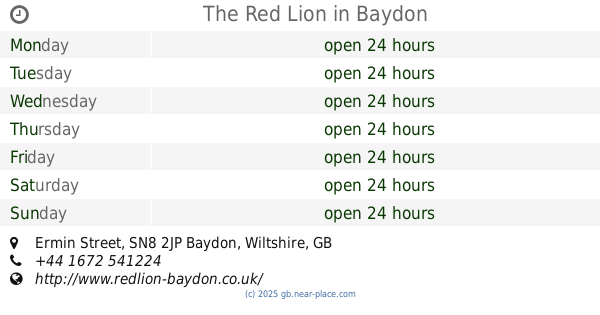
The Red Lion
Ermin Street, Baydon, Marlborough
Bar
read more
13.292 km
The Chequers Inn
23 Main Street, Wantage
Bar
read more
13.987 km
The Vines
Burford Road, Black Bourton, Bampton
Bar
read more
14.105 km
The Eight Bells,
East End, Fairford
Bar
read more
14.119 km
The Railway Inn
London Road, Fairford
Bar
read more
14.497 km
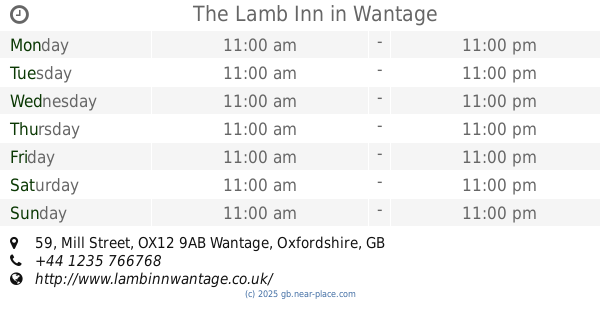
The Lamb Inn
59 Mill Street, Wantage
Bar
read more
14.531 km
The Village Tavern
Toothill, Swindon
Bar
read more
14.694 km
The King Alfred's Head
31 Market Place, Wantage
Bar
read more
15.104 km
The Red Lion
The Square, High Street, Bampton
Bar
read more
16.643 km
Beefeater Lydiard
Lydiard Fields, Great Western Way, Swindon
Bar
read more
16.742 km
14Twelve Brasserie
Lydiard Fields, Great Western Way, Swindon
Bar
read more
18.491 km
Bon Cuisine
The Old Stone Barns, High Street, Standlake, Witney
Bar
read more
18.625 km
The Black Horse
81 High Street, Standlake, Witney
Bar
read more
18.998 km
Few Inns
30 High Street, Standlake, Witney
Bar
read more
📑
all categories
Accounting
Administrative area level 1
Administrative area level 2
Airport
Amusement park
Aquarium
Art gallery
Atm
Bakery
Bank
Bar
Beauty salon
Bicycle store
Book store
Bowling alley
Bus station
Cafe
Campground
Car dealer
Car rental
Car repair
Car wash
Casino
Cemetery
Church
City hall
Clothing store
Colloquial area
Convenience store
Courthouse
Dentist
Department store
Doctor
Electrician
Electronics store
Embassy
Establishment
Finance
Fire station
Florist
Food
Funeral home
Furniture store
Gas station
General contractor
Grocery or supermarket
Gym
Hair care
Hardware store
Health
Hindu Temple
Home goods store
Hospital
Insurance agency
Jewelry store
Laundry
Lawyer
Library
Light rail station
Liquor store
Local government office
Locality
Locksmith
Lodging
Meal delivery
Meal takeaway
Mosque
Movie rental
Movie theater
Moving company
Museum
Natural feature
Neighborhood
Night club
Painter
Park
Parking
Pet store
Pharmacy
Physiotherapist
Place of worship
Plumber
Point of interest
Police
Political
Post office
Premise
Real estate agency
Restaurant
Roofing contractor
Route
Rv park, camping
School
Shoe store
Shopping mall
Spa
Stadium
Storage
Store
Subpremise
Subway station
Supermarket
Synagogue
Taxi stand
Train station
Transit station
Travel agency
University
Veterinary care
Zoo
administrative area level 3
administrative area level 4
sublocality level 1
↑