Bar nearby Foresters Arms
United Kingdom
Bar nearby Foresters Arms
Foresters Arms
4 Highbanks Close, Welling Det Forenede Kongerige
contacts phone
:
+44
Latitude:
51.4753716
, Longitude:
0.1085426
read more
nearest Bar
6 m
M&B
Highbanks Close, Welling
Bar
read more
1.449 km
Five Rivers - Authentic North Indian Cuisine
Plumstead Common Road/35 The Slade, London
Bar
read more
1.938 km
We-Anchor-In-Hope
Bellegrove Road, Shooter's Hill, Welling
Bar
read more
2.697 km
The Falcon Harvester
Lingfield Crescent, London
Bar
read more
2.799 km
The Wrong Un
234-236 Broadway, Bexleyheath
Bar
read more
2.931 km
Pradas Mediterranean Bar & Grill
198-200 Broadway, Bexleyheath
Bar
read more
3.004 km
The Rose
179 Broadway, Bexleyheath
Bar
read more
3.069 km
Delicio restaurant (Bexleyheath)
157 Broadway, Bexleyheath
Bar
read more
3.139 km
The Kings Arms
156 Broadway, Bexleyheath
Bar
read more
3.168 km
Bexleyheath Working Mens Club
Royal Oak Road, Bexleyheath
Bar
read more
3.227 km
The Travellers Home
Long Lane, Bexley Heath
Bar
read more
3.233 km
Brewers Fayre Bexley Heath
51 Albion Road, Bexleyheath
Bar
read more
3.392 km
The Red Lion
6 Red Lion Place, London
Bar
read more
3.438 km
Furze Wren
Broadway Square, Bexleyheath Shopping Centre, 6 Market Place, Bexleyheath
Bar
read more
3.438 km
The Furze Wren
Broadway Square, Bexleyheath Shopping Centre, 6 Market Place, Bexleyheath
Bar
read more
3.494 km
Chinagaga
58 Mayplace Road West, Bexleyheath
Bar
read more
3.542 km
Jolly Millers
111 Mayplace Road West, Bexleyheath
Bar
read more
3.769 km
Cast Iron Grill
1 Broadway, Bexleyheath
Bar
read more
3.784 km
Prince Albert
2 Broadway, Bexleyheath
Bar
read more
3.795 km
The Castle Tavern
179 Powis Street, London
Bar
read more
3.879 km
The Mitre
United Kingdom
Bar
read more
4.044 km
The California
12 Albert Road, London
Bar
read more
4.549 km
Thefreehost
1 Spindle Close, London
Bar
read more
5.367 km
The Crayford Arms
37 Crayford High Street, Dartford
Bar
read more
5.484 km
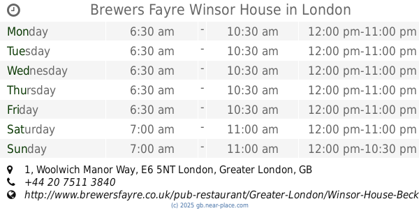
Brewers Fayre Winsor House
1 Woolwich Manor Way, London
Bar
read more
📑
all categories
Accounting
Administrative area level 1
Administrative area level 2
Airport
Amusement park
Aquarium
Art gallery
Atm
Bakery
Bank
Bar
Beauty salon
Bicycle store
Book store
Bowling alley
Bus station
Cafe
Campground
Car dealer
Car rental
Car repair
Car wash
Casino
Cemetery
Church
City hall
Clothing store
Colloquial area
Convenience store
Courthouse
Dentist
Department store
Doctor
Electrician
Electronics store
Embassy
Establishment
Finance
Fire station
Florist
Food
Funeral home
Furniture store
Gas station
General contractor
Grocery or supermarket
Gym
Hair care
Hardware store
Health
Hindu Temple
Home goods store
Hospital
Insurance agency
Jewelry store
Laundry
Lawyer
Library
Light rail station
Liquor store
Local government office
Locality
Locksmith
Lodging
Meal delivery
Meal takeaway
Mosque
Movie rental
Movie theater
Moving company
Museum
Natural feature
Neighborhood
Night club
Painter
Park
Parking
Pet store
Pharmacy
Physiotherapist
Place of worship
Plumber
Point of interest
Police
Political
Post office
Premise
Real estate agency
Restaurant
Roofing contractor
Route
Rv park, camping
School
Shoe store
Shopping mall
Spa
Stadium
Storage
Store
Subpremise
Subway station
Supermarket
Synagogue
Taxi stand
Train station
Transit station
Travel agency
University
Veterinary care
Zoo
administrative area level 3
administrative area level 4
sublocality level 1
↑