Bar nearby The Cricketers Inn
United Kingdom
Bar nearby The Cricketers Inn
The Cricketers Inn
Curdridge Lane Curdridge, Southampton Reino Unido
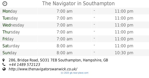
contacts phone
:
+44
Latitude:
50.927429
, Longitude:
-1.233311
read more
nearest Bar
2.193 km
The Railway Inn Botley
Station Hill, Curdridge, Southampton
Bar
read more
2.232 km
The Black Dog
Winchester Rd, Southampton
Bar
read more
2.353 km
Wheatsheaf Inn
Botley Rd, Southampton
Bar
read more
2.417 km
The Old Forge Inn
Winchester Road, Southampton
Bar
read more
2.568 km
Kings Country Bar & Restaurant
Kings Corner, Southampton
Bar
read more
2.687 km
Samuel's Rest public house
Upper Church Road, Southampton
Bar
read more
2.819 km
Farmers Home
Heathen Street, Durley, Southampton
Bar
read more
2.822 km
The Hidden Tap
Mill Hill, Southampton
Bar
read more
2.822 km
The Hidden Tap
Botley, Southampton
Bar
read more
2.863 km
The Old Mill Restaurant
Botley Mills, Mill Hill, Botley, Southampton
Bar
read more
2.908 km
The Brewery Bar
10 Winchester Street, Botley, Southampton
Bar
read more
2.968 km
The Bugle Inn
10 High Street, Botley, Southampton
Bar
read more
3.001 km
Dolphin
9 High Street, Botley, Southampton
Bar
read more
3.015 km
The Horse & Jockey
Botley Road, Curbridge, Southampton
Bar
read more
3.183 km
The Crown Inn
The Square, Bishop's Waltham, Southampton
Bar
read more
3.235 km
The Barleycorn Inn
Basingwell Street Lower, Bishop's Waltham, Southampton
Bar
read more
3.264 km
Giorgio's Mediterranean Restaurant and Bar
8 High Street, Southampton
Bar
read more
3.415 km
The Bunch Of Grapes
Saint Peter's Street, Bishop's Waltham, Southampton
Bar
read more
4.398 km
The King's Head
The Square, Wickham, Fareham
Bar
read more
4.738 km
Harvester Whiteley
Whiteley Way, Fareham
Bar
read more
4.769 km
The Roebuck Inn
Droxford Road, Kingsmead, Fareham, Wickham
Bar
read more
6.142 km
Cricketers Arms
455 Fair Oak Road, Eastleigh
Bar
read more
6.25 km
Bar Blacks
30, 32 Trafford Road, Fair Oak, Eastleigh
Bar
read more
6.718 km
The Navigator
286 Bridge Road, Southampton
Bar
read more
6.77 km
Ideal Leisure
Swanwick Marina, Swanwick Shore, Southampton
Bar
read more
📑
all categories
Accounting
Administrative area level 1
Administrative area level 2
Airport
Amusement park
Aquarium
Art gallery
Atm
Bakery
Bank
Bar
Beauty salon
Bicycle store
Book store
Bowling alley
Bus station
Cafe
Campground
Car dealer
Car rental
Car repair
Car wash
Casino
Cemetery
Church
City hall
Clothing store
Colloquial area
Convenience store
Courthouse
Dentist
Department store
Doctor
Electrician
Electronics store
Embassy
Establishment
Finance
Fire station
Florist
Food
Funeral home
Furniture store
Gas station
General contractor
Grocery or supermarket
Gym
Hair care
Hardware store
Health
Hindu Temple
Home goods store
Hospital
Insurance agency
Jewelry store
Laundry
Lawyer
Library
Light rail station
Liquor store
Local government office
Locality
Locksmith
Lodging
Meal delivery
Meal takeaway
Mosque
Movie rental
Movie theater
Moving company
Museum
Natural feature
Neighborhood
Night club
Painter
Park
Parking
Pet store
Pharmacy
Physiotherapist
Place of worship
Plumber
Point of interest
Police
Political
Post office
Premise
Real estate agency
Restaurant
Roofing contractor
Route
Rv park, camping
School
Shoe store
Shopping mall
Spa
Stadium
Storage
Store
Subpremise
Subway station
Supermarket
Synagogue
Taxi stand
Train station
Transit station
Travel agency
University
Veterinary care
Zoo
administrative area level 3
administrative area level 4
sublocality level 1
↑