Gas station nearby Shell
United Kingdom
Gas station nearby Shell
Shell
A3 South, Liphook United Kingdom
contacts phone
:
+44
Latitude:
51.0828639
, Longitude:
-0.819136
read more
nearest Gas station
2 m
Shell
A3 T South, Liphook
Gas station
read more
101 m
Shell
A3, T North, Liphook
Gas station
read more
101 m
Shell
A3, Liphook
Gas station
read more
4.274 km
Woolmer Service Station Ltd
1 Woolmer Way, Bordon
Gas station
read more
4.299 km
Shell
High Street, Bordon
Gas station
read more
4.343 km
Jet Petrol Station
1 Woolmer Way, Bordon
Gas station
read more
6.502 km
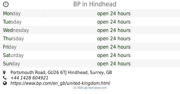
BP
Portsmouth Road, Hindhead
Gas station
read more
9.89 km
Gulf
Main Road, Farnham
Gas station
read more
9.962 km
ATM (Total Filling Station)
Main Road, Bucks Horn Oak, Guildford
Gas station
read more
14.447 km
Marks & Spencer Farnham BP
A31 Farnham By Pass, Farnham
Gas station
read more
24.726 km
ATM (Shell Meadows)
Woodbridge Road, Guildford
Gas station
read more
24.737 km
Shell
Woodbridge Road, Guildford
Gas station
read more
24.842 km
Esso
127-129 London Road, Waterlooville
Gas station
read more
24.888 km
Shell
200-202 Worplesdon Road, Guildford
Gas station
read more
24.895 km
Waitrose Petrol
46A Somertons Close, Guildford
Gas station
read more
25.263 km
ATM (Frimley Green Filling Station)
259 Frimley Green Road, Frimley Green
Gas station
read more
26.921 km
Sainsbury's Petrol Station
58 Hambledon Road, Portsmouth, Waterlooville
Gas station
read more
27.348 km
Shell Select
222 London Road, Waterlooville
Gas station
read more
27.386 km
BP
London Road, Guildford
Gas station
read more
27.428 km
BP
97 Park Lane, Havant
Gas station
read more
27.747 km
Asda Petrol
Havant
Gas station
read more
28.213 km
Esso
Bagshot Road, Brookwood, Woking
Gas station
read more
28.357 km
Morrisons Petrol Station
91 Worting Road, Basingstoke
Gas station
read more
29.534 km
B P Service Station
A3, Ripley By-Pass, Woking
Gas station
read more
30.701 km
Waitrose Petrol
Woking
Gas station
read more
📑
all categories
Accounting
Administrative area level 1
Administrative area level 2
Airport
Amusement park
Aquarium
Art gallery
Atm
Bakery
Bank
Bar
Beauty salon
Bicycle store
Book store
Bowling alley
Bus station
Cafe
Campground
Car dealer
Car rental
Car repair
Car wash
Casino
Cemetery
Church
City hall
Clothing store
Colloquial area
Convenience store
Courthouse
Dentist
Department store
Doctor
Electrician
Electronics store
Embassy
Establishment
Finance
Fire station
Florist
Food
Funeral home
Furniture store
Gas station
General contractor
Grocery or supermarket
Gym
Hair care
Hardware store
Health
Hindu Temple
Home goods store
Hospital
Insurance agency
Jewelry store
Laundry
Lawyer
Library
Light rail station
Liquor store
Local government office
Locality
Locksmith
Lodging
Meal delivery
Meal takeaway
Mosque
Movie rental
Movie theater
Moving company
Museum
Natural feature
Neighborhood
Night club
Painter
Park
Parking
Pet store
Pharmacy
Physiotherapist
Place of worship
Plumber
Point of interest
Police
Political
Post office
Premise
Real estate agency
Restaurant
Roofing contractor
Route
Rv park, camping
School
Shoe store
Shopping mall
Spa
Stadium
Storage
Store
Subpremise
Subway station
Supermarket
Synagogue
Taxi stand
Train station
Transit station
Travel agency
University
Veterinary care
Zoo
administrative area level 3
administrative area level 4
sublocality level 1
↑