Hospital nearby Nevill Hospital
United Kingdom
Hospital nearby Nevill Hospital
Nevill Hospital
Laburnum Avenue, Hove Reino Unido
contacts phone
:
+44
Latitude:
50.841933
, Longitude:
-0.1923461
read more
nearest Hospital
146 m
Mill View
Hove
Hospital
read more
1.038 km
Tree of Life Centre
143-145 Portland Road, Brighton and Hove, Hove
Hospital
read more
1.387 km
Bupa Health Centre Brighton
70 New Church Road, Hove
Hospital
read more
1.423 km
Aldrington Day Hospital
Aldrington House, 35 New Church Road, Hove
Hospital
read more
1.668 km
Clinic 9 Medical Center
Khaleej Road, Dammam, Eastern Province
Hospital
read more
1.736 km
Sackville Road Surgery
1 Goldstone Villas, Hove
Hospital
read more
1.776 km
Caruana and Laws
212 Church Road, Hove
Hospital
read more
1.926 km
Boots hearingcare
25 George Street, Hove
Hospital
read more
2.24 km
Life Line Screening
All Saints Church Hall, Eaton Road, Hove
Hospital
read more
2.304 km
Private GP Brighton
40 Wilbury Road, Hove
Hospital
read more
2.311 km
South Downs Podiatry
40 Wilbury Road, Brighton
Hospital
read more
2.311 km
The Pain Care Clinic
40 Wilbury Road, Hove
Hospital
read more
2.339 km
Barbara Bishop Acupuncture
18 Wilbury Crescent, Hove
Hospital
read more
2.539 km
Soreh Levy Acupuncture
24 Hampstead Road, Brighton
Hospital
read more
2.68 km
Charter Medical Centre
88 Davigdor Road, Hove
Hospital
read more
2.829 km
Spire Montefiore Plastic & Cosmetic Surgery Clinic
Spire Montefiore Hospital, 2 Montefiore Road, Hove
Hospital
read more
2.831 km
Sussex Spine Solutions
2 Montefiore Road, Hove
Hospital
read more
2.834 km
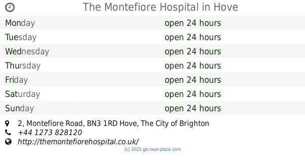
The Montefiore Hospital
2 Montefiore Road, Hove
Hospital
read more
2.865 km
Hove Natural Health Clinic
33 Montefiore Road
Hospital
read more
2.865 km
Hove Natural Health Clinic
33 Montefiore Road, Hove
Hospital
read more
3.087 km
New Priory Vets Brighton
10 The Deneway, London Road, Brighton
Hospital
read more
3.418 km
Gledhill Solicitors
1 Powis Square, Brighton
Hospital
read more
4.011 km
Boots hearingcare
129 North Street, Brighton
Hospital
read more
4.155 km
County Hospital & Mortuary Equipment
13 Westfield Crescent, Brighton
Hospital
read more
4.773 km
Ardingly Court Surgery
1 Ardingly Street, Brighton
Hospital
read more
📑
all categories
Accounting
Administrative area level 1
Administrative area level 2
Airport
Amusement park
Aquarium
Art gallery
Atm
Bakery
Bank
Bar
Beauty salon
Bicycle store
Book store
Bowling alley
Bus station
Cafe
Campground
Car dealer
Car rental
Car repair
Car wash
Casino
Cemetery
Church
City hall
Clothing store
Colloquial area
Convenience store
Courthouse
Dentist
Department store
Doctor
Electrician
Electronics store
Embassy
Establishment
Finance
Fire station
Florist
Food
Funeral home
Furniture store
Gas station
General contractor
Grocery or supermarket
Gym
Hair care
Hardware store
Health
Hindu Temple
Home goods store
Hospital
Insurance agency
Jewelry store
Laundry
Lawyer
Library
Light rail station
Liquor store
Local government office
Locality
Locksmith
Lodging
Meal delivery
Meal takeaway
Mosque
Movie rental
Movie theater
Moving company
Museum
Natural feature
Neighborhood
Night club
Painter
Park
Parking
Pet store
Pharmacy
Physiotherapist
Place of worship
Plumber
Point of interest
Police
Political
Post office
Premise
Real estate agency
Restaurant
Roofing contractor
Route
Rv park, camping
School
Shoe store
Shopping mall
Spa
Stadium
Storage
Store
Subpremise
Subway station
Supermarket
Synagogue
Taxi stand
Train station
Transit station
Travel agency
University
Veterinary care
Zoo
administrative area level 3
administrative area level 4
sublocality level 1
↑