Night club nearby The Asuyum
Coronavirus disease (COVID-19) Situation
confirmed cases
24910387
deaths
232112
United Kingdom
Night club nearby The Asuyum
The Asuyum
2 Hampton Street, Birmingham United Kingdom
contacts phone
:
+44
Latitude:
52.4882146
, Longitude:
-1.902347
read more
nearest Night club
138 m
K S Lounge & Banqueting
60-62 Constitution Hill, Birmingham
Night club
read more
157 m
Truth Nightclub Birmingham
51 Saint George's Street, Birmingham
Night club
read more
315 m
The Tunnel Club
Livery Street, Birmingham
Night club
read more
498 m
Birmingham Blue Nile Restaurant
28 Great Hampton Street, Birmingham
Night club
read more
645 m
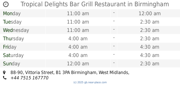
Tropical Delights Bar Grill Restaurant
88-90 Vittoria Street, Birmingham
Night club
read more
667 m
Rendezvous
Chi Bar, 61 Newhall Street, Birmingham
Night club
read more
729 m
Bushwackers
103 Edmund Street, Birmingham
Night club
read more
731 m
BHANGRA
710, 27 Colmore Row, Birmingham
Night club
read more
732 m
Carolyn Rowe - Shirley Bassey Tribute
27 Colmore Row, Birmingham
Night club
read more
737 m
Bramka
1-4 Hockley Hill, Birmingham
Night club
read more
797 m
La Reference Bar & Restaurant
160 Hockley Hill, Birmingham
Night club
read more
916 m
Warstone centre
154 Warstone Lane, Birmingham
Night club
read more
1.098 km
Prestige Restaurant & Bar Club
42 Summer Hill Road, Birmingham
Night club
read more
1.253 km
Reflex Broad Street
36-37 Broad Street, Birmingham
Night club
read more
1.266 km
Walkabout Inn
266A-271 Broad Street, Birmingham
Night club
read more
1.272 km
Vista Rooms @ Barclaycard Arena
National Indoor Arena, Birmingham
Night club
read more
1.488 km
Bambu
1 Wrottesley Street, Birmingham
Night club
read more
1.516 km
Nuvo
Eleven Brindley Place, 2 Brunswick Square, Birmingham
Night club
read more
1.518 km
Sobar
86 Hurst Street, Birmingham
Night club
read more
1.566 km
Indi Vidual Bar Birmingham
The Arcadian Centre, Hurst Street, Birmingham
Night club
read more
1.622 km
Chic Ltd
28 Horse Fair, Birmingham
Night club
read more
1.699 km
Legs 11 Broad Street
193-194 Broad Street, Birmingham
Night club
read more
1.782 km
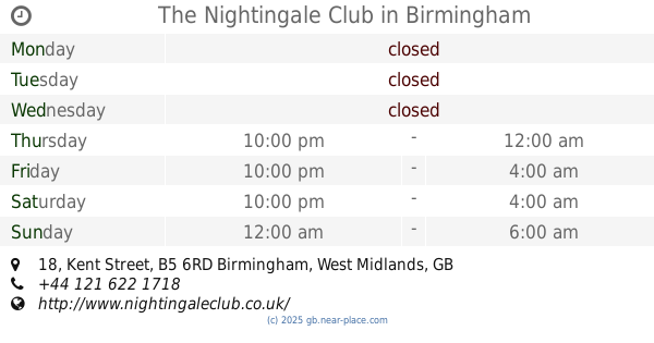
The Nightingale Club
18 Kent Street, Birmingham
Night club
read more
1.935 km
Eclipse
Moseley Street, Birmingham
Night club
read more
1.962 km
The Core Club
135 Sherlock Street, Birmingham
Night club
read more
📑
all categories
Accounting
Administrative area level 1
Administrative area level 2
Airport
Amusement park
Aquarium
Art gallery
Atm
Bakery
Bank
Bar
Beauty salon
Bicycle store
Book store
Bowling alley
Bus station
Cafe
Campground
Car dealer
Car rental
Car repair
Car wash
Casino
Cemetery
Church
City hall
Clothing store
Colloquial area
Convenience store
Courthouse
Dentist
Department store
Doctor
Electrician
Electronics store
Embassy
Establishment
Finance
Fire station
Florist
Food
Funeral home
Furniture store
Gas station
General contractor
Grocery or supermarket
Gym
Hair care
Hardware store
Health
Hindu Temple
Home goods store
Hospital
Insurance agency
Jewelry store
Laundry
Lawyer
Library
Light rail station
Liquor store
Local government office
Locality
Locksmith
Lodging
Meal delivery
Meal takeaway
Mosque
Movie rental
Movie theater
Moving company
Museum
Natural feature
Neighborhood
Night club
Painter
Park
Parking
Pet store
Pharmacy
Physiotherapist
Place of worship
Plumber
Point of interest
Police
Political
Post office
Premise
Real estate agency
Restaurant
Roofing contractor
Route
Rv park, camping
School
Shoe store
Shopping mall
Spa
Stadium
Storage
Store
Subpremise
Subway station
Supermarket
Synagogue
Taxi stand
Train station
Transit station
Travel agency
University
Veterinary care
Zoo
administrative area level 3
administrative area level 4
sublocality level 1
↑