Park nearby Dyke Road Park
United Kingdom
Park nearby Dyke Road Park
Dyke Road Park
197 Dyke Road, Hove Vereinigtes Königreich
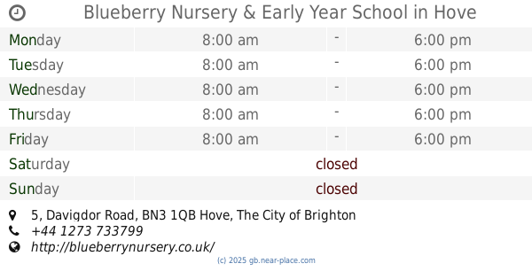
contacts phone
:
+44
Latitude:
50.8365196
, Longitude:
-0.1537781
read more
nearest Park
154 m
Hove Green
Old Shoreham Road, Hove
Park
read more
458 m
Rockery Pond
Brighton
Park
read more
657 m
Preston Manor Garden
193 Preston Road, Brighton
Park
read more
676 m
Blueberry Nursery & Early Year School
5 Davigdor Road, Hove
Park
read more
677 m
Wildflower Meadow, Preston Park
149 Preston Road, Brighton
Park
read more
684 m
Preston Park
Preston Road, Brighton
Park
read more
714 m
Rose GARDEN PRESTON PARK
The Ride, Brighton
Park
read more
764 m
Dachshund Meeting Place
Preston Park Clock Tower, The Ride, Brighton
Park
read more
773 m
Scented Garden, The
St Ann's Well Gardens, Somerhill Avenue, Hove
Park
read more
783 m
St Ann's Well Gardens
5 Furze Hill, Hove
Park
read more
807 m
Rebecca Cornwall
59 Tivoli Crescent, Brighton
Park
read more
858 m
Dyke Road Rest Garden
Dyke Road, Brighton, BN1 3JE
Park
read more
879 m
cordyline
Cumberland Lodge, Cumberland Road, Brighton
Park
read more
907 m
The Friends of St Ann’s Well Gardens
Somerhill Road, Hove
Park
read more
986 m
Brighton Greenway Pedestrian Walkway
66 Brighton Greenway, Brighton
Park
read more
995 m
Hove Recreation Ground
67 Hove Park Road, Hove
Park
read more
1.283 km
St. Nicholas Rest Garden
Reino Unido
Park
read more
1.283 km
St. Nicholas Rest Garden
Vereinigtes Königreich
Park
read more
1.3 km
Blakers Park
30 Cleveland Road, Brighton
Park
read more
1.502 km
Bedford Square
Zjednoczone Królestwo
Park
read more
1.543 km
Pelham Square
Vereinigtes Königreich
Park
read more
1.628 km
Hove Lawns
Zjednoczone Królestwo
Park
read more
1.857 km
Three Cornered Copse entrance
125 Goldstone Crescent, Hove
Park
read more
2.064 km
Tarner Park
Det Forenede Kongerige
Park
read more
2.088 km
Nevill Sports Ground
57 Nevill Avenue, Hove
Park
read more
📑
all categories
Accounting
Administrative area level 1
Administrative area level 2
Airport
Amusement park
Aquarium
Art gallery
Atm
Bakery
Bank
Bar
Beauty salon
Bicycle store
Book store
Bowling alley
Bus station
Cafe
Campground
Car dealer
Car rental
Car repair
Car wash
Casino
Cemetery
Church
City hall
Clothing store
Colloquial area
Convenience store
Courthouse
Dentist
Department store
Doctor
Electrician
Electronics store
Embassy
Establishment
Finance
Fire station
Florist
Food
Funeral home
Furniture store
Gas station
General contractor
Grocery or supermarket
Gym
Hair care
Hardware store
Health
Hindu Temple
Home goods store
Hospital
Insurance agency
Jewelry store
Laundry
Lawyer
Library
Light rail station
Liquor store
Local government office
Locality
Locksmith
Lodging
Meal delivery
Meal takeaway
Mosque
Movie rental
Movie theater
Moving company
Museum
Natural feature
Neighborhood
Night club
Painter
Park
Parking
Pet store
Pharmacy
Physiotherapist
Place of worship
Plumber
Point of interest
Police
Political
Post office
Premise
Real estate agency
Restaurant
Roofing contractor
Route
Rv park, camping
School
Shoe store
Shopping mall
Spa
Stadium
Storage
Store
Subpremise
Subway station
Supermarket
Synagogue
Taxi stand
Train station
Transit station
Travel agency
University
Veterinary care
Zoo
administrative area level 3
administrative area level 4
sublocality level 1
↑