School nearby Black Diamond of Durham
United Kingdom
School nearby Black Diamond of Durham
Black Diamond of Durham
Slake Terrace, Hartlepool Vereinigtes Königreich
contacts phone
:
+44
Latitude:
54.6900533
, Longitude:
-1.1990016
read more
nearest School
3.163 km
Scallywags Children's Day Nursery
Warrior Drive, Hartlepool
School
read more
3.748 km
Catcote Academy
193 Brierton Lane, Hartlepool
School
read more
9.517 km
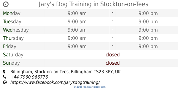
Jary's Dog Training
Billingham, Stockton-on-Tees
School
read more
9.805 km
campuss school
Billingham, Stockton-on-Tees, Billingham
School
read more
10.965 km
Saint Paul's Roman Catholic Primary School
192 Thames Road, Billingham
School
read more
11.08 km
Coatham Primary School
Coatham Road, Redcar
School
read more
11.657 km
Little Legs Day Nursery
70 Thames Road, Redcar
School
read more
12.254 km
Tummyticklers childcare nursery
Ambleside Road, Stockton-on-Tees, Billingham
School
read more
12.256 km
Tummyticklers
Mill Lane, Billingham
School
read more
13.141 km
Dimples Riverside Day Nursery
Sharrock Close, Middlesbrough
School
read more
13.303 km
Teacher Time
6nw, 38 Beaumont Road, Middlesbrough
School
read more
13.313 km
East West Childrens Centre
Sure Start Centre, Abingdon Road, Middlesbrough
School
read more
13.441 km
A.D. Norton Board Schools.
16 High Street, Stockton-on-Tees
School
read more
13.455 km
Montessori Pre-Schools Central
46 Southfield Road, Middlesbrough
School
read more
13.496 km
Breckon Hill Primary School
Breckon Hill Road, Middlesbrough
School
read more
13.531 km
Newport Primary School
Saint Paul's Road, Middlesbrough
School
read more
13.655 km
Norton Primary Academy
Berkshire Road, Norton
School
read more
14.755 km
North East Music Lessons
26 Highfield Road, Eston, Middlesbrough
School
read more
14.878 km
Nunthorpe Children's Day Nursery
The Crescent, Nunthorpe, Middlesbrough
School
read more
14.931 km
Linthorpe Community Primary School
Roman Road, Linthorpe, Middlesbrough
School
read more
15.03 km
Harrow Gate Primary Academy
Piper Knowle Rd
School
read more
15.352 km
Rosedene Nurseries
Hardwick Community Centre, Whessoe Road, Stockton-on-Tees
School
read more
15.535 km
Hilltop School
School
read more
15.923 km
Whitehouse Primary School
Dunelm Rd, Stockton-on-Tees
School
read more
16.171 km
Stockton Sixth Form College
Bishopton Road West, Stockton-on-Tees
School
read more
📑
all categories
Accounting
Administrative area level 1
Administrative area level 2
Airport
Amusement park
Aquarium
Art gallery
Atm
Bakery
Bank
Bar
Beauty salon
Bicycle store
Book store
Bowling alley
Bus station
Cafe
Campground
Car dealer
Car rental
Car repair
Car wash
Casino
Cemetery
Church
City hall
Clothing store
Colloquial area
Convenience store
Courthouse
Dentist
Department store
Doctor
Electrician
Electronics store
Embassy
Establishment
Finance
Fire station
Florist
Food
Funeral home
Furniture store
Gas station
General contractor
Grocery or supermarket
Gym
Hair care
Hardware store
Health
Hindu Temple
Home goods store
Hospital
Insurance agency
Jewelry store
Laundry
Lawyer
Library
Light rail station
Liquor store
Local government office
Locality
Locksmith
Lodging
Meal delivery
Meal takeaway
Mosque
Movie rental
Movie theater
Moving company
Museum
Natural feature
Neighborhood
Night club
Painter
Park
Parking
Pet store
Pharmacy
Physiotherapist
Place of worship
Plumber
Point of interest
Police
Political
Post office
Premise
Real estate agency
Restaurant
Roofing contractor
Route
Rv park, camping
School
Shoe store
Shopping mall
Spa
Stadium
Storage
Store
Subpremise
Subway station
Supermarket
Synagogue
Taxi stand
Train station
Transit station
Travel agency
University
Veterinary care
Zoo
administrative area level 3
administrative area level 4
sublocality level 1
↑