Train station nearby Huyton
United Kingdom
Train station nearby Huyton
Huyton
United Kingdom Vereinigtes Königreich
contacts phone
:
+44
Latitude:
53.4094629
, Longitude:
-2.8427948
read more
nearest Train station
873 m
Roby
United Kingdom
Train station
read more
3.109 km
Whiston
United Kingdom
Train station
read more
3.296 km
Prescot
United Kingdom
Train station
read more
3.375 km
Broad Green
United Kingdom
Train station
read more
4.787 km
Eccleston Park
United Kingdom
Train station
read more
5.062 km
Halewood
United Kingdom
Train station
read more
5.134 km
Rainhill
United Kingdom
Train station
read more
5.875 km
Mossley Hill
United Kingdom
Train station
read more
6.089 km
Hough Green
United Kingdom
Train station
read more
6.181 km
West Allerton
United Kingdom
Train station
read more
6.314 km
Thatto Heath
United Kingdom
Train station
read more
8.866 km
St Helens Central
Shaw Street, Saint Helens
Train station
read more
8.918 km
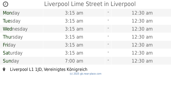
Liverpool Lime Street
United Kingdom
Train station
read more
9.092 km
Fazakerley
United Kingdom
Train station
read more
9.662 km
Walton
United Kingdom
Train station
read more
9.701 km
Moorfields
United Kingdom
Train station
read more
9.825 km
St Helens Junction
United Kingdom
Train station
read more
12.033 km
Birkenhead Central
United Kingdom
Train station
read more
12.116 km
Bebington
United Kingdom
Train station
read more
12.289 km
Port Sunlight
United Kingdom
Train station
read more
12.498 km
Seaforth & Litherland
United Kingdom
Train station
read more
12.652 km
Spital
United Kingdom
Train station
read more
12.992 km
Maghull North Station
United Kingdom
Train station
read more
13.164 km
Bromborough Rake
United Kingdom
Train station
read more
14.25 km
Birkenhead North
United Kingdom
Train station
read more
📑
all categories
Accounting
Administrative area level 1
Administrative area level 2
Airport
Amusement park
Aquarium
Art gallery
Atm
Bakery
Bank
Bar
Beauty salon
Bicycle store
Book store
Bowling alley
Bus station
Cafe
Campground
Car dealer
Car rental
Car repair
Car wash
Casino
Cemetery
Church
City hall
Clothing store
Colloquial area
Convenience store
Courthouse
Dentist
Department store
Doctor
Electrician
Electronics store
Embassy
Establishment
Finance
Fire station
Florist
Food
Funeral home
Furniture store
Gas station
General contractor
Grocery or supermarket
Gym
Hair care
Hardware store
Health
Hindu Temple
Home goods store
Hospital
Insurance agency
Jewelry store
Laundry
Lawyer
Library
Light rail station
Liquor store
Local government office
Locality
Locksmith
Lodging
Meal delivery
Meal takeaway
Mosque
Movie rental
Movie theater
Moving company
Museum
Natural feature
Neighborhood
Night club
Painter
Park
Parking
Pet store
Pharmacy
Physiotherapist
Place of worship
Plumber
Point of interest
Police
Political
Post office
Premise
Real estate agency
Restaurant
Roofing contractor
Route
Rv park, camping
School
Shoe store
Shopping mall
Spa
Stadium
Storage
Store
Subpremise
Subway station
Supermarket
Synagogue
Taxi stand
Train station
Transit station
Travel agency
University
Veterinary care
Zoo
administrative area level 3
administrative area level 4
sublocality level 1
↑