Train station nearby Moorfields
United Kingdom
Train station nearby Moorfields
Moorfields
Liverpool L2 2BL, Vereinigtes Königreich
contacts phone
:
+44
Latitude:
53.4086972
, Longitude:
-2.9891665
larger map & directions
read more
nearest Train station
457 m
Liverpool James Street
James Street, Liverpool
Train station
read more
756 m
Liverpool Central
Ranelagh Street, Liverpool
Train station
read more
756 m
Liverpool Central
54 St James St, Ranelagh Street, Liverpool
Train station
read more
795 m
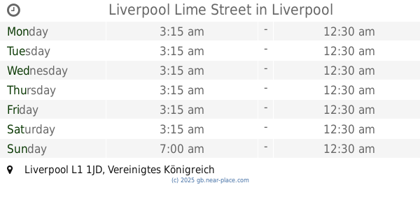
Liverpool Lime Street
United Kingdom
Train station
read more
2.268 km
Hamilton Square Station
United Kingdom
Train station
read more
2.368 km
Sandhills
United Kingdom
Train station
read more
2.792 km
Conway Park
Birkenhead
Train station
read more
2.909 km
Edge Hill
United Kingdom
Train station
read more
2.958 km
Brunswick
United Kingdom
Train station
read more
3.083 km
Birkenhead Central
United Kingdom
Train station
read more
3.205 km
Bank Hall
United Kingdom
Train station
read more
3.539 km
Birkenhead Park
United Kingdom
Train station
read more
3.621 km
Kirkdale
United Kingdom
Train station
read more
4.241 km
Bootle Oriel Road
United Kingdom
Train station
read more
4.255 km
Rock Ferry
United Kingdom
Train station
read more
4.408 km
Wavertree Technology Park
United Kingdom
Train station
read more
4.563 km
Birkenhead North
United Kingdom
Train station
read more
4.984 km
Bootle New Strand
United Kingdom
Train station
read more
5.037 km
New Brighton
United Kingdom
Train station
read more
5.747 km
Wallasey Grove Road
Groveland Road, Wallasey
Train station
read more
5.807 km
Bebington
United Kingdom
Train station
read more
5.898 km
Mossley Hill
United Kingdom
Train station
read more
6.4 km
Aigburth
United Kingdom
Train station
read more
7.561 km
Fazakerley
United Kingdom
Train station
read more
14.792 km
Rainhill
United Kingdom
Train station
read more
📑
all categories
Accounting
Administrative area level 1
Administrative area level 2
Airport
Amusement park
Aquarium
Art gallery
Atm
Bakery
Bank
Bar
Beauty salon
Bicycle store
Book store
Bowling alley
Bus station
Cafe
Campground
Car dealer
Car rental
Car repair
Car wash
Casino
Cemetery
Church
City hall
Clothing store
Colloquial area
Convenience store
Courthouse
Dentist
Department store
Doctor
Electrician
Electronics store
Embassy
Establishment
Finance
Fire station
Florist
Food
Funeral home
Furniture store
Gas station
General contractor
Grocery or supermarket
Gym
Hair care
Hardware store
Health
Hindu Temple
Home goods store
Hospital
Insurance agency
Jewelry store
Laundry
Lawyer
Library
Light rail station
Liquor store
Local government office
Locality
Locksmith
Lodging
Meal delivery
Meal takeaway
Mosque
Movie rental
Movie theater
Moving company
Museum
Natural feature
Neighborhood
Night club
Painter
Park
Parking
Pet store
Pharmacy
Physiotherapist
Place of worship
Plumber
Point of interest
Police
Political
Post office
Premise
Real estate agency
Restaurant
Roofing contractor
Route
Rv park, camping
School
Shoe store
Shopping mall
Spa
Stadium
Storage
Store
Subpremise
Subway station
Supermarket
Synagogue
Taxi stand
Train station
Transit station
Travel agency
University
Veterinary care
Zoo
administrative area level 3
administrative area level 4
sublocality level 1
↑