Cafe nearby Robinsons Cafe
Coronavirus disease (COVID-19) Situation
confirmed cases
24910387
deaths
232112
United Kingdom
Cafe nearby Robinsons Cafe
Robinsons Cafe
7 Bishopthorpe Road, York Det Forenede Kongerige
contacts phone
:
+44
Latitude:
53.951866
, Longitude:
-1.084794
read more
nearest Cafe
46 m
Trinacria
27 Bishopthorpe Road, York
Cafe
read more
63 m
The Pig
35 Bishopthorpe Road, Yotk
Cafe
read more
473 m
Tower Vue Cafe
14 Tower Street, York
Cafe
read more
611 m
Chico's
United Kingdom
Cafe
read more
614 m
Your Bike Shed
148 Micklegate, York
Cafe
read more
614 m
Micklegate Social
148 Micklegate, York
Cafe
read more
642 m
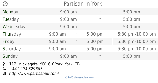
Partisan
112 Micklegate, York
Cafe
read more
651 m
Castle Tea Rooms
11A Castlegate, York
Cafe
read more
680 m
The Spurriergate Centre
Saint Michaels Chambers, Spurrier Gate, York
Cafe
read more
684 m
Hubble Bubble-Tea
York
Cafe
read more
755 m
Costa Coffee
14 High Ousegate, York
Cafe
read more
777 m
Veeno - The Italian Wine Café
7 Piccadilly, York
Cafe
read more
821 m
Bish Bash Pot
64 Walmgate, York
Cafe
read more
851 m
The Drawing Board
10-10a New Street, York
Cafe
read more
867 m
Bison Coffee House
17 Heslington Road, York
Cafe
read more
874 m
Costa Coffee
Railway Station, Station Road, York
Cafe
read more
875 m
Garden Room
Station Road, York
Cafe
read more
879 m
Greggs
15 Saint Sampsons Square, York
Cafe
read more
887 m
W M E Cafe
14 Saint Sampsons Square, York
Cafe
read more
892 m
Browns Tea House
21 Davygate, York
Cafe
read more
892 m
Hartleys
West Lodge, Lendal Bridge, York
Cafe
read more
915 m
Bettys Café Tea Rooms
6-8 Saint Helen’s Square, York
Cafe
read more
934 m
Croque-Monsieur
216 Fulford Road, York
Cafe
read more
986 m
The Attic Gallery Coffee Bar
2 Kings Square, York
Cafe
read more
1.152 km
The Mallard Cafe
National Railway Museum Great Hall, Leeman Rd, York
Cafe
read more
📑
all categories
Accounting
Administrative area level 1
Administrative area level 2
Airport
Amusement park
Aquarium
Art gallery
Atm
Bakery
Bank
Bar
Beauty salon
Bicycle store
Book store
Bowling alley
Bus station
Cafe
Campground
Car dealer
Car rental
Car repair
Car wash
Casino
Cemetery
Church
City hall
Clothing store
Colloquial area
Convenience store
Courthouse
Dentist
Department store
Doctor
Electrician
Electronics store
Embassy
Establishment
Finance
Fire station
Florist
Food
Funeral home
Furniture store
Gas station
General contractor
Grocery or supermarket
Gym
Hair care
Hardware store
Health
Hindu Temple
Home goods store
Hospital
Insurance agency
Jewelry store
Laundry
Lawyer
Library
Light rail station
Liquor store
Local government office
Locality
Locksmith
Lodging
Meal delivery
Meal takeaway
Mosque
Movie rental
Movie theater
Moving company
Museum
Natural feature
Neighborhood
Night club
Painter
Park
Parking
Pet store
Pharmacy
Physiotherapist
Place of worship
Plumber
Point of interest
Police
Political
Post office
Premise
Real estate agency
Restaurant
Roofing contractor
Route
Rv park, camping
School
Shoe store
Shopping mall
Spa
Stadium
Storage
Store
Subpremise
Subway station
Supermarket
Synagogue
Taxi stand
Train station
Transit station
Travel agency
University
Veterinary care
Zoo
administrative area level 3
administrative area level 4
sublocality level 1
↑