Bar nearby The Crazy Bear Stadhampton
United Kingdom
Bar nearby The Crazy Bear Stadhampton
The Crazy Bear Stadhampton
Bear Lane, Stadhampton Vereinigtes Königreich
contacts phone
:
+44
Latitude:
51.6808226
, Longitude:
-1.1297265
read more
nearest Bar
294 m
The Crown
Thame Road, Oxford
Bar
read more
1.055 km
Coach And Horses Inn
Chiselhampton Hill, Oxford
Bar
read more
1.059 km
The Coach & Horses Inn
Watlington Road, Chislehampton, Oxford
Bar
read more
1.988 km
The Catherine Wheel
Drayton St. Leonard, Wallingford
Bar
read more
2.985 km
The Bull Great Milton
7PS, Haseley Road, Little Milton, Oxford
Bar
read more
3.018 km
The Lamb Inn
High Street, Little Milton, Oxford
Bar
read more
3.076 km
The Lamb
2 Mill Lane, Oxford
Bar
read more
3.26 km
The Boozer
36 Brookside Estate, Chalgrove, Oxford
Bar
read more
3.699 km
The Red Lion
115 High Street, Chalgrove, Oxford
Bar
read more
3.855 km
The Village Inn
19-19A Fane Drive, Berinsfield, Wallingford
Bar
read more
4.078 km
The Seven Stars
The Green, Marsh Baldon, Oxford
Bar
read more
4.247 km
The Mole Inn
Toot Baldon, Oxford
Bar
read more
4.443 km
The Chequers Inn
Berrick Salome, Wallingford
Bar
read more
4.471 km
Garsington Sports and Social Club
Denton Lane, Garsington, Oxford
Bar
read more
4.588 km
The Chequers at Burcot
Abingdon Rd, Burcot
Bar
read more
4.589 km
Bat & Ball
High Street, Cuddesdon, Oxford
Bar
read more
4.6 km
Bat & Ball
High St, Cuddesdon, Oxford
Bar
read more
4.747 km
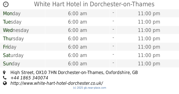
White Hart Hotel
High Street, Dorchester, Dorchester-on-Thames
Bar
read more
4.844 km
The Six Bells On The Green
Wallingford
Bar
read more
4.848 km
The Six Bells
The Green South, Warborough, Wallingford
Bar
read more
5.098 km
The Plough
Rectory Road, Oxford
Bar
read more
5.188 km
The Bull Inn
The Green, Oxford
Bar
read more
5.484 km
Home Sweet Home
Roke, Wallingford
Bar
read more
6.598 km
Bullnose Morris
Watlington Road, Oxford
Bar
read more
6.733 km
The Blackbird
Blackbird Leys Road, Oxford
Bar
read more
📑
all categories
Accounting
Administrative area level 1
Administrative area level 2
Airport
Amusement park
Aquarium
Art gallery
Atm
Bakery
Bank
Bar
Beauty salon
Bicycle store
Book store
Bowling alley
Bus station
Cafe
Campground
Car dealer
Car rental
Car repair
Car wash
Casino
Cemetery
Church
City hall
Clothing store
Colloquial area
Convenience store
Courthouse
Dentist
Department store
Doctor
Electrician
Electronics store
Embassy
Establishment
Finance
Fire station
Florist
Food
Funeral home
Furniture store
Gas station
General contractor
Grocery or supermarket
Gym
Hair care
Hardware store
Health
Hindu Temple
Home goods store
Hospital
Insurance agency
Jewelry store
Laundry
Lawyer
Library
Light rail station
Liquor store
Local government office
Locality
Locksmith
Lodging
Meal delivery
Meal takeaway
Mosque
Movie rental
Movie theater
Moving company
Museum
Natural feature
Neighborhood
Night club
Painter
Park
Parking
Pet store
Pharmacy
Physiotherapist
Place of worship
Plumber
Point of interest
Police
Political
Post office
Premise
Real estate agency
Restaurant
Roofing contractor
Route
Rv park, camping
School
Shoe store
Shopping mall
Spa
Stadium
Storage
Store
Subpremise
Subway station
Supermarket
Synagogue
Taxi stand
Train station
Transit station
Travel agency
University
Veterinary care
Zoo
administrative area level 3
administrative area level 4
sublocality level 1
↑