Bar nearby The Ferrymans Inn
United Kingdom
Bar nearby The Ferrymans Inn
The Ferrymans Inn
Bablock Hythe, Witney Vereinigtes Königreich
contacts phone
:
+44
Latitude:
51.7351157
, Longitude:
-1.3722092
read more
nearest Bar
1.698 km
The Eight Bells
High Street, Eaton, Abingdon
Bar
read more
1.973 km
Red Lion
Northmoor, Witney
Bar
read more
2.819 km
The Vine Inn
11 Abingdon Road, Cumnor, Oxford
Bar
read more
2.895 km
The Plough Inn
Eaton Road, Appleton, Abingdon
Bar
read more
3.503 km
The Greyhound
Besselsiegh, Wootton
Bar
read more
3.904 km
Few Inns
30 High Street, Standlake, Witney
Bar
read more
4.182 km
Rose Revived
New Bridge, Witney
Bar
read more
4.212 km
The Maybush
Abingdon Road, Newbridge, Witney
Bar
read more
4.236 km
The Black Horse
81 High Street, Standlake, Witney
Bar
read more
4.37 km
Bon Cuisine
The Old Stone Barns, High Street, Standlake, Witney
Bar
read more
4.721 km
The Talbot Inn
Oxford Road, Eynsham
Bar
read more
4.963 km
Bystander
Besselsleigh Road, Wootton, Abingdon
Bar
read more
6.018 km
The White Hart of Wytham OX2 8QA
Wytham, Oxford
Bar
read more
6.579 km
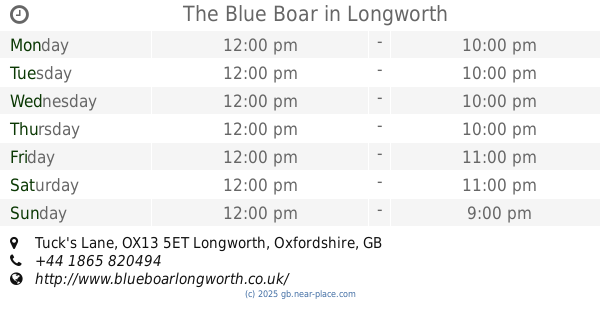
The Blue Boar
Tuck's Lane, Abingdon
Bar
read more
7.897 km
Cow and Creek
12 New Road, Oxford
Bar
read more
8.222 km
The Bear Inn
6 Alfred St, Oxford
Bar
read more
8.702 km
Hand & Shears
Church Hanborough
Bar
read more
8.786 km
Joe's Bar & Grill
260 Banbury Road, Oxford
Bar
read more
9.351 km
The Star
21 Rectory Road, Oxford
Bar
read more
9.549 km
Hawkwell House Hotel by Compass Hospitality
Church Way, Iffley village, Oxford
Bar
read more
11.021 km
The Cricketers Arms
102 Temple Road, Oxford
Bar
read more
11.478 km
Miller & Carter Kidlington
117 Bicester Road, Kidlington
Bar
read more
13.534 km
The Red Lion
High Street, Islip, Kidlington
Bar
read more
15.266 km
The Chequers at Burcot
Abingdon Rd, Burcot
Bar
read more
16.905 km
Ruby Jacks
Market Place, 26, Faringdon
Bar
read more
📑
all categories
Accounting
Administrative area level 1
Administrative area level 2
Airport
Amusement park
Aquarium
Art gallery
Atm
Bakery
Bank
Bar
Beauty salon
Bicycle store
Book store
Bowling alley
Bus station
Cafe
Campground
Car dealer
Car rental
Car repair
Car wash
Casino
Cemetery
Church
City hall
Clothing store
Colloquial area
Convenience store
Courthouse
Dentist
Department store
Doctor
Electrician
Electronics store
Embassy
Establishment
Finance
Fire station
Florist
Food
Funeral home
Furniture store
Gas station
General contractor
Grocery or supermarket
Gym
Hair care
Hardware store
Health
Hindu Temple
Home goods store
Hospital
Insurance agency
Jewelry store
Laundry
Lawyer
Library
Light rail station
Liquor store
Local government office
Locality
Locksmith
Lodging
Meal delivery
Meal takeaway
Mosque
Movie rental
Movie theater
Moving company
Museum
Natural feature
Neighborhood
Night club
Painter
Park
Parking
Pet store
Pharmacy
Physiotherapist
Place of worship
Plumber
Point of interest
Police
Political
Post office
Premise
Real estate agency
Restaurant
Roofing contractor
Route
Rv park, camping
School
Shoe store
Shopping mall
Spa
Stadium
Storage
Store
Subpremise
Subway station
Supermarket
Synagogue
Taxi stand
Train station
Transit station
Travel agency
University
Veterinary care
Zoo
administrative area level 3
administrative area level 4
sublocality level 1
↑