Bar nearby The Plough Inn
United Kingdom
Bar nearby The Plough Inn
The Plough Inn
Eaton Road, Appleton, Abingdon United Kingdom
contacts phone
:
+44
Latitude:
51.7099932
, Longitude:
-1.3611735
read more
nearest Bar
1.774 km
The Greyhound
Besselsiegh, Wootton
Bar
read more
1.919 km
The Eight Bells
High Street, Eaton, Abingdon
Bar
read more
2.626 km
Red Lion
Northmoor, Witney
Bar
read more
2.849 km
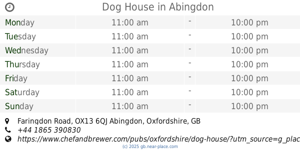
Dog House
Faringdon Road, Abingdon
Bar
read more
2.895 km
The Ferrymans Inn
Bablock Hythe, Witney
Bar
read more
3.131 km
Bystander
Besselsleigh Road, Wootton, Abingdon
Bar
read more
3.332 km
The Vine Inn
11 Abingdon Road, Cumnor, Oxford
Bar
read more
3.67 km
The Black Horse
Faringdon Road, Abingdon
Bar
read more
3.864 km
Rose Revived
New Bridge, Witney
Bar
read more
3.874 km
The Maybush
Abingdon Road, Newbridge, Witney
Bar
read more
4.761 km
The Fox Inn
Fox Lane, Boars Hill, Oxford
Bar
read more
4.819 km
Few Inns
30 High Street, Standlake, Witney
Bar
read more
4.963 km
The Crown
1 Packhorse Lane, Marcham, Abingdon
Bar
read more
4.986 km
The Black Horse
81 High Street, Standlake, Witney
Bar
read more
5.08 km
Bon Cuisine
The Old Stone Barns, High Street, Standlake, Witney
Bar
read more
5.08 km
Prince Of Wales
60 Barrow Road, Shippon, Abingdon
Bar
read more
5.518 km
Greene King Distribution
Abingdon Distribution Centre, 23 Nuffield Way, Abingdon
Bar
read more
5.685 km
Waggon & Horses
Faringdon Road, Abingdon
Bar
read more
6.228 km
Beefeater Ock Mill
Marcham Road, Abingdon
Bar
read more
6.322 km
Seacourt Bridge
West Way, Oxford, Botley
Bar
read more
6.414 km
White Horse
189 Ock Street, Abingdon
Bar
read more
6.461 km
Tap Social Movement
27, Curtis Industrial Estate, North Hinksey Lane, Oxford
Bar
read more
8.335 km
Cow and Creek
12 New Road, Oxford
Bar
read more
8.605 km
The Bear Inn
6 Alfred St, Oxford
Bar
read more
13.241 km
The Chequers at Burcot
Abingdon Rd, Burcot
Bar
read more
📑
all categories
Accounting
Administrative area level 1
Administrative area level 2
Airport
Amusement park
Aquarium
Art gallery
Atm
Bakery
Bank
Bar
Beauty salon
Bicycle store
Book store
Bowling alley
Bus station
Cafe
Campground
Car dealer
Car rental
Car repair
Car wash
Casino
Cemetery
Church
City hall
Clothing store
Colloquial area
Convenience store
Courthouse
Dentist
Department store
Doctor
Electrician
Electronics store
Embassy
Establishment
Finance
Fire station
Florist
Food
Funeral home
Furniture store
Gas station
General contractor
Grocery or supermarket
Gym
Hair care
Hardware store
Health
Hindu Temple
Home goods store
Hospital
Insurance agency
Jewelry store
Laundry
Lawyer
Library
Light rail station
Liquor store
Local government office
Locality
Locksmith
Lodging
Meal delivery
Meal takeaway
Mosque
Movie rental
Movie theater
Moving company
Museum
Natural feature
Neighborhood
Night club
Painter
Park
Parking
Pet store
Pharmacy
Physiotherapist
Place of worship
Plumber
Point of interest
Police
Political
Post office
Premise
Real estate agency
Restaurant
Roofing contractor
Route
Rv park, camping
School
Shoe store
Shopping mall
Spa
Stadium
Storage
Store
Subpremise
Subway station
Supermarket
Synagogue
Taxi stand
Train station
Transit station
Travel agency
University
Veterinary care
Zoo
administrative area level 3
administrative area level 4
sublocality level 1
↑