Lodging nearby Birchfield
United Kingdom
Lodging nearby Birchfield
Birchfield
Rhuallt nr. St Asaph United Kingdom
contacts phone
:
+44
Latitude:
53.262585
, Longitude:
-3.399246
read more
nearest Lodging
484 m
Tan Yr Onnen Guesthouse
Waen, Saint Asaph
Lodging
read more
484 m
Tan Yr Onnen Guesthouse Hotel
Waen, Saint Asaph
Lodging
read more
1.337 km
Ffynnon Beuno Retreat
Saint Asaph
Lodging
read more
2.577 km
North Wales Holiday Cottage
Summerhill Court, Tremeirchion
Lodging
read more
2.605 km
Tyn Y Coed
Dyserth
Lodging
read more
2.651 km
Richmond Hall
Chester Street, Saint Asaph
Lodging
read more
2.672 km
Cae Gwyn Cottages
Unnamed Road, 0UN, Saint Asaph
Lodging
read more
2.965 km
Beuno’s Huts
Beunos Huts, Ffynnon Beuno Bodfari Road, Tremeirchion
Lodging
read more
3.069 km
The Oriel Country Hotel & Spa
Upper Denbigh Road, Saint Asaph
Lodging
read more
3.418 km
Coed Duon B&B
Tremerichion, Saint Asaph
Lodging
read more
3.564 km
Ruthin Castle
The Roe, Saint Asaph
Lodging
read more
3.616 km
Talardy Hotel
The Roe, Saint Asaph
Lodging
read more
3.656 km
Bach Y Graig Farmhouse
Tremeirchion, Saint Asaph
Lodging
read more
4.498 km
The Trefnant Inn
Denbigh
Lodging
read more
4.851 km
Pleasant View Caravan Park
Abbey Road, Rhuddlan
Lodging
read more
4.997 km
Garden Suite apartment with Hot Tub
Gwenallt, Abbey Road, Rhuddlan
Lodging
read more
5.56 km
Rhuddlan House
10 Clos-Y-Berllan, Rhuddlan, Rhyl
Lodging
read more
5.574 km
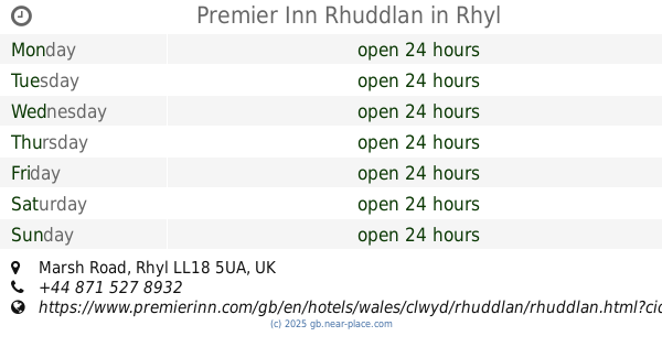
Premier Inn Rhuddlan
Marsh Road, Rhyl
Lodging
read more
5.777 km
Bird's Nest
Rhuddlan
Lodging
read more
6.808 km
Faenol Fawr Country House Hotel
Bodelwyddan, St. Asaph, Denbighshire
Lodging
read more
7.39 km
Pheasant Fields
Lloc nr. Holywell
Lodging
read more
8.244 km
Millers Retreat
Plymouth Copse
Lodging
read more
11.851 km
Genfa Garrig
Brynford, Holywell
Lodging
read more
14.949 km
Tyn Y Mynydd Bach
Holywell
Lodging
read more
20.521 km
Glan Llyn
Pant Du Road, Mold
Lodging
read more
📑
all categories
Accounting
Administrative area level 1
Administrative area level 2
Airport
Amusement park
Aquarium
Art gallery
Atm
Bakery
Bank
Bar
Beauty salon
Bicycle store
Book store
Bowling alley
Bus station
Cafe
Campground
Car dealer
Car rental
Car repair
Car wash
Casino
Cemetery
Church
City hall
Clothing store
Colloquial area
Convenience store
Courthouse
Dentist
Department store
Doctor
Electrician
Electronics store
Embassy
Establishment
Finance
Fire station
Florist
Food
Funeral home
Furniture store
Gas station
General contractor
Grocery or supermarket
Gym
Hair care
Hardware store
Health
Hindu Temple
Home goods store
Hospital
Insurance agency
Jewelry store
Laundry
Lawyer
Library
Light rail station
Liquor store
Local government office
Locality
Locksmith
Lodging
Meal delivery
Meal takeaway
Mosque
Movie rental
Movie theater
Moving company
Museum
Natural feature
Neighborhood
Night club
Painter
Park
Parking
Pet store
Pharmacy
Physiotherapist
Place of worship
Plumber
Point of interest
Police
Political
Post office
Premise
Real estate agency
Restaurant
Roofing contractor
Route
Rv park, camping
School
Shoe store
Shopping mall
Spa
Stadium
Storage
Store
Subpremise
Subway station
Supermarket
Synagogue
Taxi stand
Train station
Transit station
Travel agency
University
Veterinary care
Zoo
administrative area level 3
administrative area level 4
sublocality level 1
↑