Bank nearby Santander
Coronavirus disease (COVID-19) Situation
confirmed cases
24910387
deaths
232112
United Kingdom
Bank nearby Santander
Santander
4-8 Bond Street, London Vereinigtes Königreich
contacts phone
:
+44
Latitude:
51.5124267
, Longitude:
-0.3061851
read more
nearest Bank
47 m
TSB Bank
31 New Broadway, London
Bank
read more
87 m
Brittania
20 New Broadway, London
Bank
read more
95 m
The Co-operative Bank - Ealing
London
Bank
read more
95 m
The Co-op Bank
London
Bank
read more
103 m
Yorkshire Building Society
41 High Street, London
Bank
read more
131 m
RBS
14 High Street, London
Bank
read more
195 m
LIOYDS TSB
67 The Broadway, London
Bank
read more
278 m
Barclays Bank
Ealing Broadway Shopping Centre, 53 The Broadway, London
Bank
read more
312 m
Dhfl uk office
2 Ealing Green, London
Bank
read more
312 m
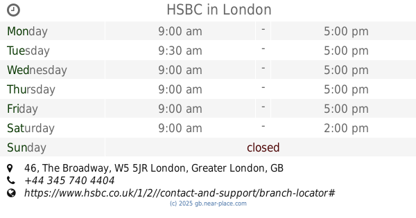
HSBC
46 The Broadway, Ealing, London
Bank
read more
328 m
Lloyds Bank
45 The Broadway, Ealing, London
Bank
read more
328 m
Lloyds Bank
45 The Broadway, London
Bank
read more
368 m
Metro Bank
The Townhouse, The Broadway, London
Bank
read more
369 m
Allied Irish Bank (GB)
85 Uxbridge Road, Ealing Cross, London
Bank
read more
386 m
NatWest
1 The Mall, London
Bank
read more
387 m
Halifax
64, 65 The Mall, Ealing, London
Bank
read more
387 m
Halifax
64-65 The Mall, London
Bank
read more
518 m
Handelsbanken Ealing
1, 48 The Mall, London
Bank
read more
921 m
NatWest
162 Uxbridge Road, London
Bank
read more
1.006 km
Lloyds Bank
1, Bedford House, West Ealing, London
Bank
read more
1.22 km
Barclays Bank
41 Broadway, London
Bank
read more
1.39 km
Santander
114 Broadway, London
Bank
read more
2.215 km
DIXIPAY LTD
Boundary House Business Centre, Boston Road, London
Bank
read more
2.229 km
Cavendish Asset Management
West World, London
Bank
read more
2.609 km
NatWest
139 High Street, London
Bank
read more
📑
all categories
Accounting
Administrative area level 1
Administrative area level 2
Airport
Amusement park
Aquarium
Art gallery
Atm
Bakery
Bank
Bar
Beauty salon
Bicycle store
Book store
Bowling alley
Bus station
Cafe
Campground
Car dealer
Car rental
Car repair
Car wash
Casino
Cemetery
Church
City hall
Clothing store
Colloquial area
Convenience store
Courthouse
Dentist
Department store
Doctor
Electrician
Electronics store
Embassy
Establishment
Finance
Fire station
Florist
Food
Funeral home
Furniture store
Gas station
General contractor
Grocery or supermarket
Gym
Hair care
Hardware store
Health
Hindu Temple
Home goods store
Hospital
Insurance agency
Jewelry store
Laundry
Lawyer
Library
Light rail station
Liquor store
Local government office
Locality
Locksmith
Lodging
Meal delivery
Meal takeaway
Mosque
Movie rental
Movie theater
Moving company
Museum
Natural feature
Neighborhood
Night club
Painter
Park
Parking
Pet store
Pharmacy
Physiotherapist
Place of worship
Plumber
Point of interest
Police
Political
Post office
Premise
Real estate agency
Restaurant
Roofing contractor
Route
Rv park, camping
School
Shoe store
Shopping mall
Spa
Stadium
Storage
Store
Subpremise
Subway station
Supermarket
Synagogue
Taxi stand
Train station
Transit station
Travel agency
University
Veterinary care
Zoo
administrative area level 3
administrative area level 4
sublocality level 1
↑